表
裏
発行:日野観光協会
配布場所:日野まちかど感応館(9:00~17:00)、近江日野商人ふるさと館(9:00~16:00)
配布日:2020年9月19日~
取得日:2020年12月26日
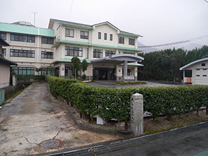
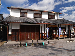
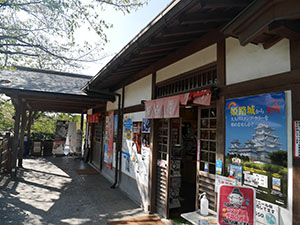
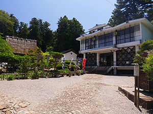
日野まちかど感応館
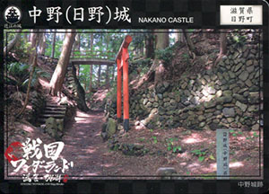
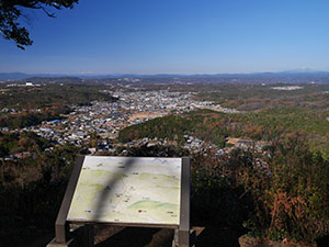
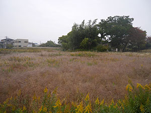
日野川ダム湖のほとりに中野城跡が残っている。
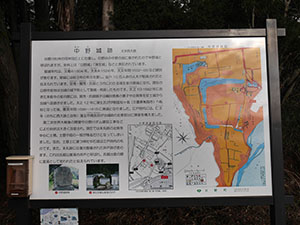
案内板によると、土塁と堀など一部が残るのみ
稲荷神社境内として残る土塁。石垣は境内整備によるもの。
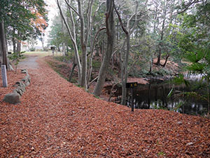
堀の一部が池として残る。
城データ
所在地:滋賀県蒲生郡日野町西大路
時代:天文年間/天正12年以降
主要城主:蒲生定秀、賢秀、氏郷
現況・形態:土塁や堀の一部、井戸跡などの遺構が残る
表
裏
発行:甲賀市観光まちづくり協会
配布場所:甲賀市ひと・まち街道交流館(9:00~17:00 月曜・年末年始は休館)
配布日:2020年4月~
取得日:2020年12月26日
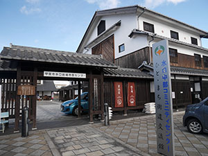
甲賀市ひと・まち街道交流館
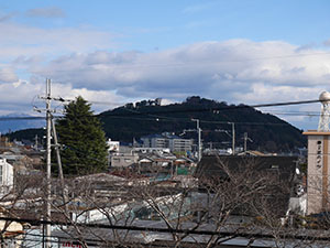
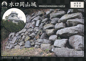
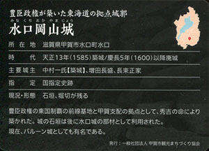
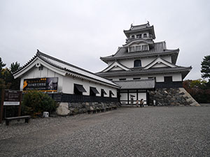
水口城資料館2Fから見た水口岡山城
城データ
所在地:滋賀県甲賀市水口町水口
時代:天正13年築城/慶長5年以降廃城
主要城主:中村一氏、増田長盛、長束正家
指定:国指定史跡
現況・形態:石垣、堀切が残る
表
裏
発行:甲賀市観光まちづくり協会
配布場所:水口城資料館(10:00~17:00 木・金曜日、年末年始休館/入館料要)、甲賀市ひと・まち街道交流館(9:00~17:00 月曜・年末年始は休館)
配布日:2020年9月19日~
取得日:2020年12月26日
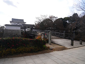
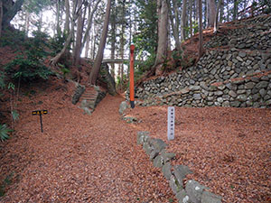
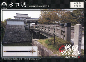
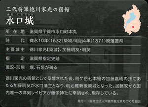
水口城の外桝形虎口
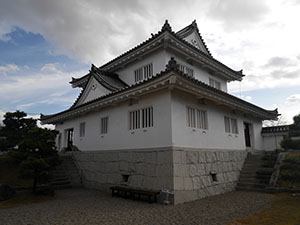
水口城資料館
甲賀市では水口城と水口岡山城の2枚配布している。近江の城カードHPでもどちらももらえるような書き方をしてあるが、資料館でもらえるのは水口城のみだった。

水口城模型
外桝形虎口と内桝形虎口の2つの桝形虎口が印象的な構造
内桝形虎口
本丸隅矢倉台
外桝形虎口の隅に資料館の建物が建つが元は本丸隅にはあるが、外桝形虎口にはなかった
城データ
所在地:滋賀県甲賀市水口町本丸
時代:寛永10年築城/明治4年廃藩置県
主要城主:徳川家光、加藤明友・明英
指定:滋賀県指定史跡
現況・形態:堀、石垣が残る
表
裏
発行:猿飛佐助実行委員会
配布場所:旧青少年自然道場(10:00~16:00 土日祝)
配布日:2020年4月~
取得日:2020年12月26日
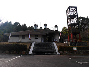
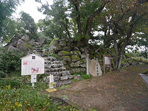
旧青少年自然道場
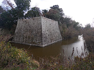
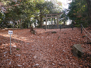
休日のみ開館していて、三雲城展を無料で見られる。
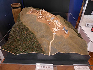
三雲城の模型もあるので先に見ておくとイメージがわく。
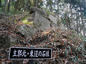
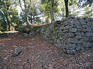
主郭東面の石垣
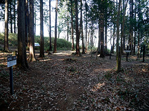
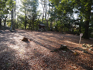
主郭
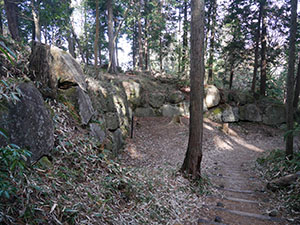
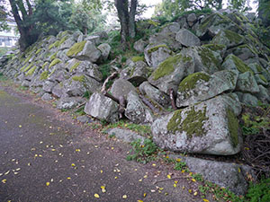
主郭南面の桝形虎口石垣
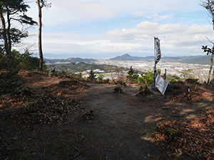
二の曲輪は北方に景色が広がり、NHK朝ドラ「スカーレット」のロケ地になった。
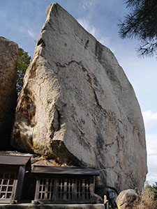
八丈岩
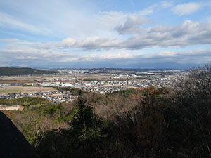
八丈岩からの景色
城データ
所在地:滋賀県湖南市吉永
時代:長享元年築城/元亀元年落城
主要城主:三雲典膳
指定:滋賀県指定史跡
現状・形態:桝形虎口(穴太積石垣)、井戸、土塁が残る
表
裏
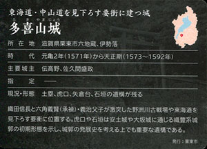
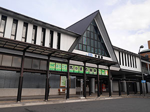
発行:栗東市
配布場所:栗東観光案内所(平日8:30~17:15、休日8:30~12:00)
配布日:2020年9月19日~2020年12月28日
取得日:2020年12月26日
JR手原駅の2階
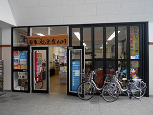
栗東観光案内所
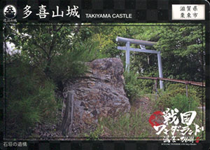
城データ
所在地:滋賀県栗東市六地蔵、伊勢落
時代:元亀2年から天正期
主要城主:伝高野、佐久間盛政
現況・形態:土塁、虎口、矢倉台、石垣の遺構が残る
表
裏
配布場所:妻木公民館、崇禅寺
配布日:2020年1月~ 2000枚
取得日:2020年12月24日
妻木城跡とともにネットで入手した。
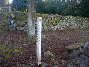
妻木城士屋敷跡の前に観光駐車場があり、麓から妻木城への登城口がある。
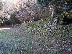
曲輪の石垣が残る。
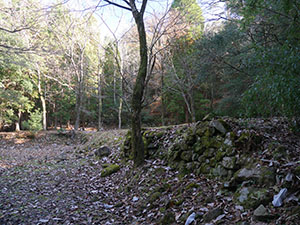
屋敷跡は3段の階段上に曲輪が連なっている。
一番奥の石垣は崩れた部分も多い。
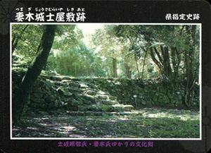
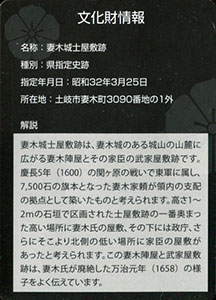
文化財情報
名称:妻木城士屋敷跡
種別:県指定史跡
指定年月日:昭和32年3月25日
所在地:土岐市妻木町3090番地の1外
表
裏
配布場所:八幡神社社務所、妻木公民館
配布日:2020年1月~ 2000枚
取得日:2020年12月24日
先日八幡神社に参拝したときには同所にはなく、ネットで入手した。
妻木城の三の曲輪は大変見晴らしがよく、雪を被った御嶽山や白山、そして恵那山が見えた。
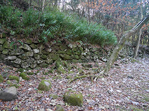
二の曲輪の虎口
二の曲輪と一の曲輪の段差の石垣がカードになっている。
一の曲輪には城山八幡神社が鎮座する。
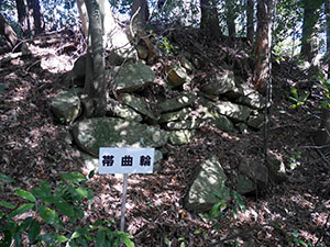
一の曲輪に沿った帯曲輪でも石垣を見ることができる。
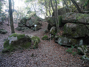
城跡のあちこちで巨石を見ることができる。石垣に使う石には事欠かない環境
文化財情報
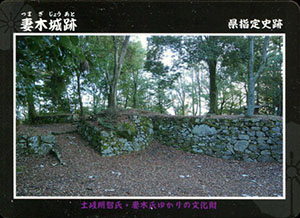
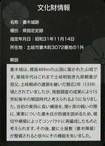
名称:妻木城跡
種別:県指定史跡
指定年月日:昭和31年11月14日
所在地:土岐市妻木町3072番地の1外
表
裏
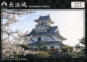
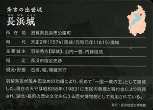
発行:長浜城歴史博物館
配布場所:長浜城歴史博物館(9:00~17:00。入館者限定)
配布日:2020年4月~12月
取得日:2020年11月7日
長浜城歴史博物館
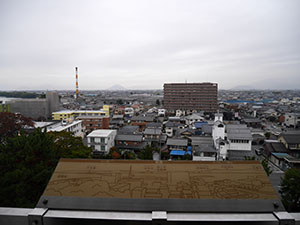
最上階から北方
山本山や虎御前山、小谷山はうっすらと見えるものの竹生島は見えない。
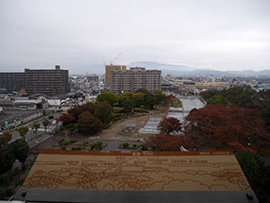
東方
正面に伊吹山、その麓に横山城がある。
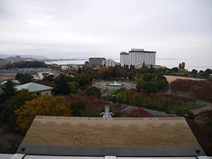
南方
彦根山がうっすら見える。
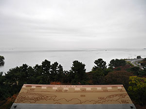
西方
天気が良ければ琵琶湖越しに比叡山や安土山が見えるはずだが
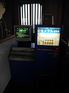
最上階に懐かしい記念メダルが。10年前はいろいろな城にあったが最近は見かけなくなった。
以前集めていて10城以上は持っている。横の打刻機で日付を打っているとあまりの音の大きさに目立つんだよね。
城データ
所在地:滋賀県長浜市公園町
時代:天正2年築城/元和元年廃城
主要城主:羽柴秀吉(築城)、山内一豊、内藤信成
指定:長浜市指定史跡
現況・形態:石垣、堀、模擬天守
表
裏
発行:米原市
配布場所:番場資料館(10:00~16:00、土日のみ祝日休み)
配布日:2020年9月19日~
取得日:2020年11月7日
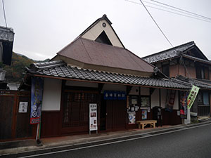
番場資料館。地元有志により土日のみ開館している。
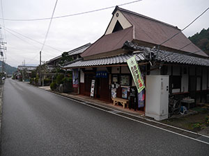
前の道路は旧中山道
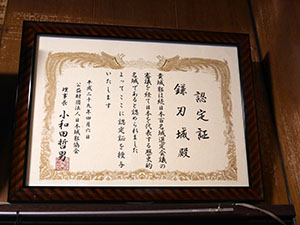
続100名城認定証
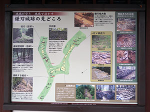
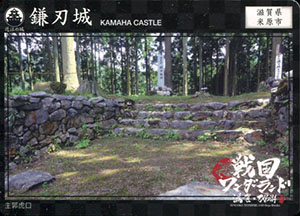
鎌刃城に関する情報や写真が多数展示されている。
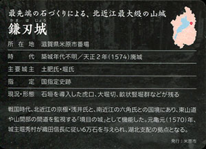
城データ
所在地:滋賀県米原市番場
時代:築城年代不明/天正2年廃城
主要城主:土肥氏・堀氏
指定:国指定史跡
現況・形態:石垣を導入した虎口、大堀切、畝状竪堀群などが残る
表
裏
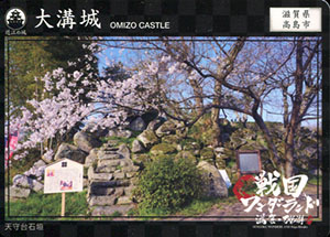
表
裏
発行:大溝の水辺景観まちづくり協議会・高島市教育委員会
配布場所:大溝まち並み案内所総門(10:00~17:00、水・木曜休み)
配布日:2020年4月~
取得日:2020年11月7日
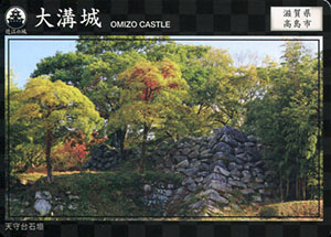
天守台への入口は三の丸跡
天守台周辺の野原は本丸になるが、内堀が埋め立てられているので規模が分かりづらい。
天守台
織豊系城郭に見られる大きな隅石
総門
カードは現在2種類配布されている。残部が少なくなり、増刷するにあたり新デザインとなったそうだ。旧デザインがなくなり次第1種類配布となるが、桜が新カードか。
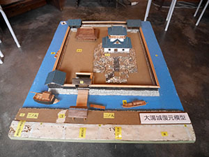
大溝城模型
城データ
所在地:滋賀県高島市勝野
時代:天正6年築城
主要城主:織田信澄(築城)、丹羽長秀、京極高次
指定:高島市指定史跡(天守台)
現況・形態:天守台石垣が残る
表
裏
発行:公益社団法人びわ湖大津観光協会
配布場所:坂本観光案内所(9:00~17:00)
配布日:2020年4月~
取得日:2020年11月3日
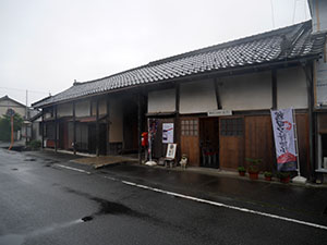
坂本観光案内所
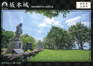
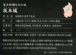
城データ
所在地:滋賀県大津市下阪本
時代:元亀2年築城/天正14年廃城
主要城主:明智光秀(築城)、丹羽長秀、杉原家次、浅野長政
指定:
現況・形態:城下町の縄張、石垣の一部(湖中・琵琶湖の渇水時に出現)
表
裏
配布日:2020年8月16日~
取得日:2020年10月13日
取得額:300円
重文現存三重櫓シリーズとして5城が販売開始された。
明石公園管理事務所で御城印とともに販売されている。
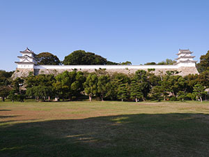
三重櫓が2棟
復元された土塀でつながった姿は絵になる。
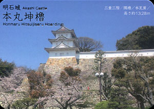
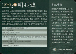
本丸巽櫓
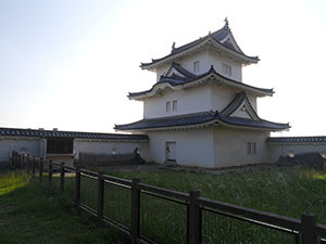
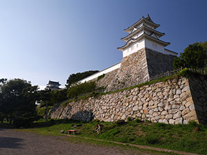
本丸坤櫓
本丸坤櫓
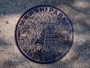
明石公園のマンホールにも本丸坤櫓が描かれている。
城データ
所在地:兵庫県明石市明石公園1-27
別名:喜春城
築城年代:元和5年(1619)
築城者:小笠原忠真
主要城主:小笠原氏、松平(戸田)氏、大久保氏、松平(藤井)氏、本多氏、松平(越前)氏
指定文化財:重要文化財(本丸坤櫓、本丸巽櫓)、国史跡
再建建造物:本丸土塀(復元)
表
裏
配布日:2018年10月28日~
取得日:2020年10月13日
取得額:300円
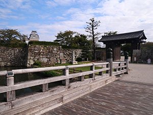
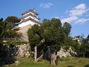
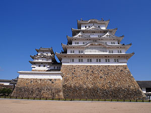
久しぶりの姫路城
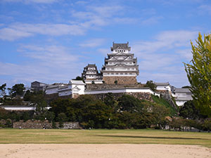
平成の修復のときは何度も来たが、終了してから初めて来た。
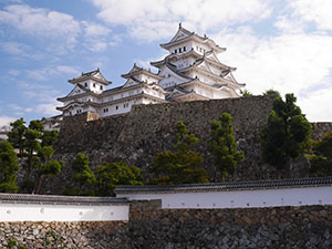
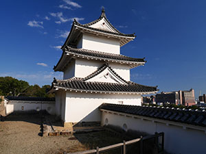
カードは菱の門をくぐり、三国堀越しに見た角度。大天守と小天守2棟が見える。
平日開門直後は人もまばらでゆっくりと見学できた。
平成の修理の後、入場料の値上げがあったことも足が遠のいた原因だったのだが、城カードは出口売店で販売されている。
入城しないと買えないため、多少高くても仕方がない。
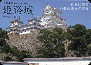
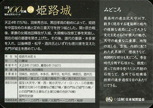
城データ
所在地:姫路市本丸6
別名;白鷺城
築城年代:天正8年(1580)、慶長6年(1601)
築城者:羽柴秀吉、池田輝政
主要城主:羽柴氏、池田氏、本多氏、奥平氏、松平氏、榊原氏、酒井氏
天守(現存):望楼型、連立式
指定文化財:国宝(大天守、東・西・乾小天守、イ・ロ・ハ・ニの渡櫓)、重要文化財(イの渡櫓など櫓27棟、菱の門など城門15棟、との四門東方土塀など土塀32棟の合計74棟)、国特別史跡
再建建造物:黒門一・二の門・袖塀、太鼓門一・二の門・袖塀
表
裏
配布日:2020年9月26日~ 200枚
配布場所:白山市観光連盟
取得額:200円
白山市観光連盟
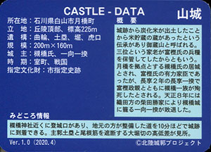
城データ
種別:山城
所在地:石川県白山市月橋町
立地:丘陵頂部、標高225m
遺構:曲輪、土塁、堀、虎口
規模:200m X 160m
城主:槻橋氏、一向一揆
時期:室町、戦国
指定文化財:市指定史跡
表
裏
配布日:2020年9月26日~ 200枚
配布場所:白山市観光連盟
取得額:200円
白山市観光連盟
城データ
種別:山城
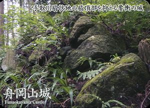
所在地:石川県白山市八幡町
別称:白山城、八幡城、劔城
立地:丘陵頂部、標高186m
遺構:曲輪、土塁、堀、石垣、虎口、櫓台、土橋
規模:200m X 130m
城主:坪坂平九郎、若林長門守、佐久間盛政、高畠定吉
時期:室町、戦国
指定文化財:市指定史跡
表
裏
配布日:2020年9月26日~ 200枚
配布場所:白山市観光連盟
取得額:200円
白山市観光連盟
城データ
種別:山城
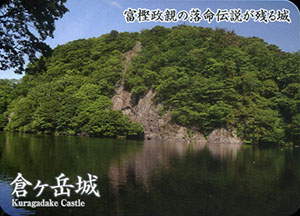
所在地:石川県金沢市倉ヶ嶽町
別称:鞍ヶ嶽城
立地:丘陵頂部、標高565m
遺構:曲輪、土塁、井戸
規模:310m X 130m
城主:林氏、富樫氏、一向一揆
時期:室町、戦国
表
裏
配布日:2020年9月26日~ 200枚
配布場所:白山市観光連盟
取得額:200円
白山市観光連盟
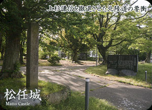
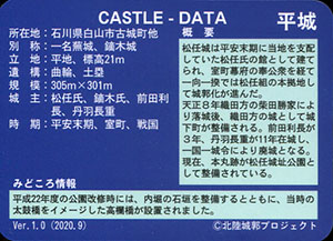
城データ
種別:平城
所在地:石川県白山市古城町他
別称:一名蕪城、鏑木城
立地:平地、標高21m
遺構:曲輪、土塁
規模:305m X 301m
城主:松任氏、鏑木氏、前田利長、丹羽長重
時期:平安末期、室町、戦国
表
裏
配布日:2020年9月26日~ 200枚
配布場所:白山市観光連盟
取得額:200円
白山市観光連盟
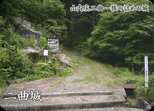
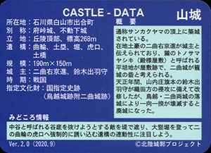
城データ
種別:山城
所在地:石川県白山市出合町
別称:府峠城、不動下城
立地:丘陵頂部、標高268m
遺構:曲輪、土塁、堀、虎口、土橋
規模:190m X 150m
城主:二曲右京進、鈴木出羽守
時期:戦国
指定文化財:国指定史跡(鳥越城跡附二曲城跡)
表
裏
配布日:2020年9月26日~ 200枚
配布場所:白山市観光連盟
取得額:200円
白山市観光連盟
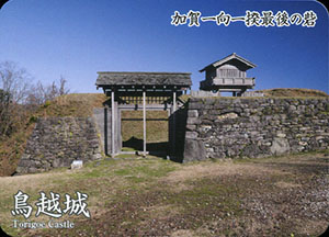
城データ
種別:山城
所在地:石川県白山市三坂町他
別称:別宮城
立地:丘陵頂部、標高312m
遺構:曲輪、土塁、堀、石垣、虎口、櫓台、土橋
規模:440m X 130m
城主:鈴木出羽守、柴田勝家、佐久間盛政
時期:戦国
指定文化財:国指定史跡(鳥越城跡附二曲城跡)
表
裏
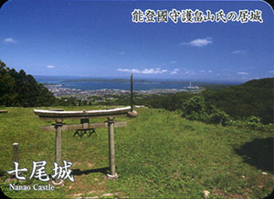
配布日:2020年9月20日~ 400枚
配布場所:七尾城史資料館
取得額:200円
七尾城史資料館
城データ
種別:山城
所在地:石川県七尾市古屋敷町他
立地:丘陵頂部、標高310m
遺構:曲輪、土塁、堀、石垣、虎口、土橋、櫓台
規模:2500m X 1000m
城主:能登畠山氏、上杉謙信、前田利家
時期:室町、戦国
指定文化財:国指定史跡
何でも集めたくなるのが男のサガ(性)。ゲット!カードコレクション