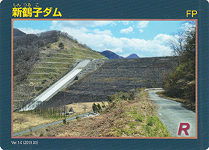
表
裏
配布場所:村山北部土地改良区(平日のみ9:00~17:00、年末年始を除く)
配布日:2024年12月11日~
取得日:2025年3月28日
取得の追加事項:
ネットで入手した。
ダムデータ
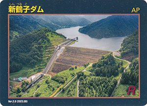
所在地:山形県尾花沢市大字鶴子
河川名:最上川水系丹生川
型式:中央コア型ロックフィルダム
ゲート:フラップゲートX1門
堤高:96.0m
堤頂長:283.9m
総貯水容量:31500千m3
管理者:山形県
本体着工:1972年
完成年:1990年
表
裏
配布場所:村山北部土地改良区(平日のみ9:00~17:00、年末年始を除く)
配布日:2024年12月11日~
取得日:2025年3月28日
取得の追加事項:
ネットで入手した。
ダムデータ
所在地:山形県尾花沢市大字鶴子
河川名:最上川水系丹生川
型式:中央コア型ロックフィルダム
ゲート:フラップゲートX1門
堤高:96.0m
堤頂長:283.9m
総貯水容量:31500千m3
管理者:山形県
本体着工:1972年
完成年:1990年
表
裏
表
裏
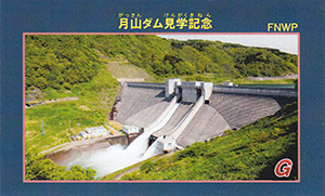
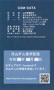
配布場所:月山ダム管理所(9:00~16:30、土・日・祝日を含む、12月~3月は平日のみ)
配布日:
取得日:2024年12月25日
取得の追加事項:見学者に配布。
ネットで入手した。
ダムデータ
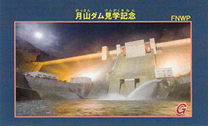
所在地:山形県鶴岡市
河川名:赤川水系梵字川
型式:重力式コンクリートダム
ゲート:コンジットラジアルゲートX2門、クレストラジアルゲートX2門、ホロージェットバルブX2基
堤高:123m
堤頂長:393m
総貯水容量:6500万m3
管理者:国土交通省
本体着工:1988年
完成年:2001年
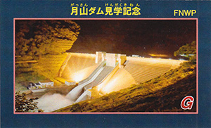
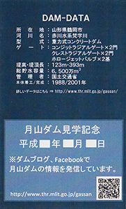
表
裏
配布場所:月山ダム管理所(9:00~16:30、土・日・祝日を含む、12月~3月は平日のみ)
配布日:2007年7月~
取得日:2024年11月30日
取得の追加事項:
ネットで入手した。
ダムデータ
所在地:山形県鶴岡市
河川名:赤川水系梵字川
型式:重力式コンクリートダム
ゲート:コンジットラジアルゲートX2門、クレストラジアルゲートX2門、ホロージェットバルブX2基
堤高:123m
堤頂長:393m
総貯水容量:6500万m3
管理者:国土交通省
本体着工:1988年
完成年:2001年
表
裏
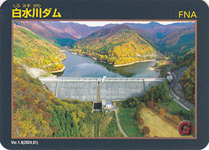
配布場所:白水川ダム管理所(10:00~15:00、月・水・金曜のみ、年末年始を除く)、村山総合支庁山形統合ダム管理課(9:00~16:30、土・日・祝日・年末年始を除く)
配布日:2024年4月30日~
取得日:2024年6月6日
取得の追加事項:山形統合ダム管理課で配布希望の場合はダムを訪れた証明(写真等)が必要
ネットで入手した。
ダムデータ
所在地:山形県東根市泉郷
河川名:最上川水系白水川
型式:重力式コンクリートダム
ゲート:なし
堤高:54.5m
堤頂長:367m
総貯水容量:530万m3
管理者:山形県
本体着工:1979年
完成年:1991年
表
裏
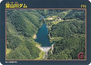
配布場所:留山川ダム管理所(9:00~17:00、土・日・祝日・年末年始を除く)、村山総合支庁山形統合ダム管理課(9:00~16:30、土・日・祝日・年末年始を除く)
配布日:2024年4月30日~
取得日:2024年5月7日
取得の追加事項:山形統合ダム管理課で配布希望の場合はダムを訪れた証明(写真等)が必要
ネットで入手した。
ダムデータ
所在地:山形県天童市山口
河川名:最上川水系押切川支川留山川
型式:重力式コンクリートダム
ゲート:なし
堤高:46m
堤頂長:115m
総貯水容量:112万m3
管理者:山形県
本体着工:1993年
完成年:2011年
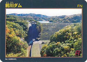
表
裏
配布場所:前川ダム管理所(9:00~17:00、土・日・祝日・年末年始を除く)、村山総合支庁山形統合ダム管理課(9:00~16:30、土・日・祝日・年末年始を除く)
配布日:2024年4月30日~
取得日:2024年5月7日
取得の追加事項:山形統合ダム管理課で配布希望の場合はダムを訪れた証明(写真等)が必要
ネットで入手した。
ダムデータ
所在地:山形県上山市川口
河川名:最上川水系前川
型式:ロックフィルダム
ゲート:なし
堤高:50m
堤頂長:265.5m
総貯水容量:440万m3
管理者:山形県
本体着工:1974年
完成年:1983年
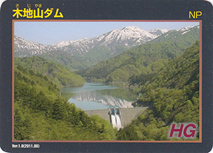
表
裏
配布場所:置賜総合支庁西置賜地域振興局内 総合案内窓口(8:30~17:00、土・日・祝日・年末年始を除く)
配布日:2011年8月~
取得日:2024年2月28日
取得の追加事項:
ネットで入手した。
ダムデータ
所在地:山形県長井市
河川名:最上川水系置賜野川
型式:中空重力式コンクリートダム
ゲート:テンダーゲートX2門
堤高:46.0m
堤頂長:168.2m
総貯水容量:8200千m3
管理者:山形県
本体着工:1959年
完成年:1961年
表
裏
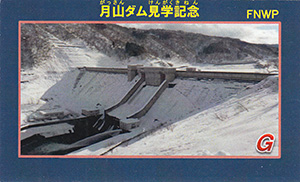
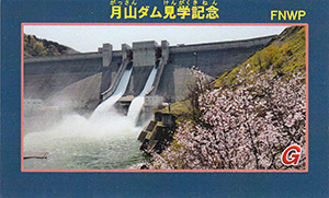
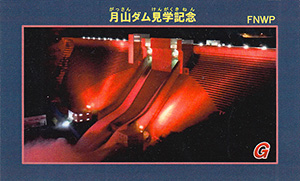
表
裏
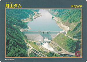
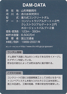
配布場所:月山ダム管理所(9:00~16:30、土・日・祝日を含む、12月~3月は平日のみ)
配布日:
取得日:2023年10月23日
取得の追加事項:見学者に配布。
ネットで入手した。
ダムデータ
所在地:山形県鶴岡市
河川名:赤川水系梵字川
型式:重力式コンクリートダム
ゲート:コンジットラジアルゲートX2門、クレストラジアルゲートX2門、ホロージェットバルブX2基
堤高:123m
堤頂長:393m
総貯水容量:6500万m3
管理者:国土交通省
本体着工:1988年
完成年:2001年
表
裏
カード種別:ダムカード公認
配布場所:最上総合支庁 高坂ダム管理課(9:00~16:00、土・日・祝日・年末年始を除く)
配布日:2010年8月~
取得日:2023年8月14日
取得の追加事項:
ネットで入手した。
ダムデータ
所在地:山形県最上郡真室川町
河川名:最上川水系鮭川
型式:重力式コンクリートダム
ゲート:クレストラジアルゲートX1門
堤高:57m
堤頂長:118.7m
総貯水容量:1905千m3
管理者:山形県
本体着工:1963年
完成年:1967年
表
裏
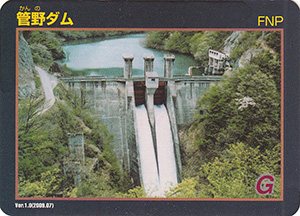
カード種別:ダムカード公認
配布場所:長井ダム管理支所(9:00~17:00、土・日・祝日を含む)
配布日:2009年7月~ 配布終了
取得日:2023年8月11日
取得の追加事項:
ネットで入手した。長井ダムの供用開始によりダム湖に水没したので限定配布され終了した。
ダムデータ
所在地:山形県長井市
河川名:最上川水系置賜野川
型式:重力式コンクリートダム
ゲート:ローラーゲートX2門
堤高:44.5m
堤頂長:81.8m
総貯水容量:4470千m3
管理者:山形県
本体着工:1951年
完成年:1953年
表
裏
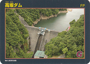
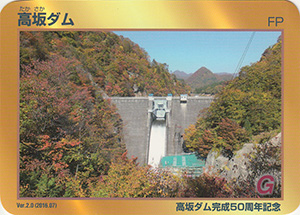
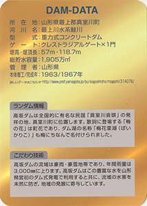
カード種別:ダムカード公認
配布場所:最上総合支庁 高坂ダム管理課(9:00~16:00、土・日・祝日・年末年始を除く)
配布日:2016年7月~
取得日:2023年8月9日
取得の追加事項:
ネットで入手した。
ダムデータ
所在地:山形県最上郡真室川町
河川名:最上川水系鮭川
型式:重力式コンクリートダム
ゲート:クレストラジアルゲートX1門
堤高:57m
堤頂長:118.7m
総貯水容量:1905千m3
管理者:山形県
本体着工:1963年
完成年:1967年
表
裏
カード種別:ダムカード公認
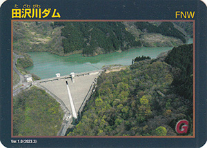
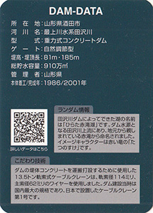
配布場所:田沢川ダム管理所(9:30~15:30、土・日・祝・年末年始を除く)
配布日:2023年3月~
取得日:2023年7月3日
取得の追加事項:
ネットで入手した。
ダムデータ
所在地:山形県酒田市
河川名:最上川水系田沢川
型式:重力式コンクリートダム
ゲート:自然調節型
堤高:81m
堤頂長:185m
総貯水容量:910万m3
管理者:山形県
本体着工:1986年
完成年:2001年
表
裏
配布場所:村山北部土地改良区(平日のみ9:00~17:00、年末年始を除く)
配布日:2022年~
取得日:2023年6月21日
取得の追加事項:
ネットで入手した。
ダムデータ
所在地:山形県尾花沢市
河川名:最上川水系丹生川
型式:中央コア型ロックフィルダム
ゲート:フラップゲートX1門
堤高:96.0m
堤頂長:283.9m
総貯水容量:31500千m3
管理者:山形県
本体着工:1972年
完成年:1990年
表
裏
配布場所:月山ダム管理所(9:00~16:30、土・日・祝日を含む、12月~3月は平日のみ)
配布日:
取得日:2023年5月17日
取得の追加事項:見学者に配布。
ネットで入手した。
ダムデータ
所在地:山形県鶴岡市
河川名:赤川水系梵字川
型式:重力式コンクリートダム
ゲート:コンジットラジアルゲートX2門、クレストラジアルゲートX2門、ホロージェットバルブX2基
堤高:123m
堤頂長:393m
総貯水容量:6500万m3
管理者:国土交通省
本体着工:1988年
完成年:2001年
表
裏
配布場所:月山ダム管理所(9:00~16:30、土・日・祝日を含む、12月~3月は平日のみ)
配布日:
取得日:2023年5月9日
取得の追加事項:見学者に配布。
ネットで入手した。
ダムデータ
所在地:山形県鶴岡市
河川名:赤川水系梵字川
型式:重力式コンクリートダム
ゲート:コンジットラジアルゲートX2門、クレストラジアルゲートX2門、ホロージェットバルブX2基
堤高:123m
堤頂長:393m
総貯水容量:6500万m3
管理者:国土交通省
本体着工:1988年
完成年:2001年
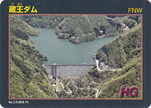
表
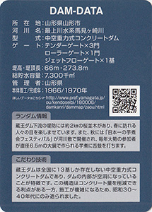
裏
配布場所:蔵王ダム管理所(10:00~15:30、土日祝日・年末年始を除く)
配布日:2018年11月~
取得日:2023年5月9日
取得の追加事項:
ネットで入手した。
ダムデータ
所在地:山形県山形市
河川名:最上川水系馬見ヶ崎川
型式:中空重力式コンクリートダム
ゲート:テンダーゲートX3門、ローラゲートX1門、ジェットフローゲートX1基
堤高:66m
堤頂長:273.8m
総貯水容量:7300千m3
管理者:山形県
本体着工:1966年
完成年:1970年
表
裏
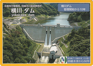
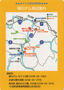
カード種別:ダムカード公認
配布場所:きてくろ館、横川ダム管理支所(9:00~17:00、土・日・祝日を含む)
配布日:2018年
取得日:2023年4月26日
取得の追加事項:
ネットで入手した。
表
裏
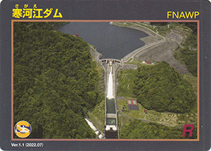
カード種別:ダムカード公認
配布場所:最上川ダム統合管理事務所(寒河江ダム)(9:00~17:00、土・日・祝日を含む)
配布日:2022年7月~
取得日:2023年4月22日
取得の追加事項:
ネットで入手した。
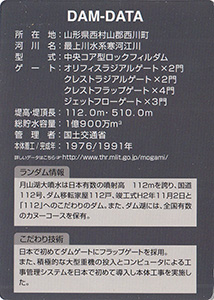
ダムデータ
所在地:山形県西村山郡西川町
河川名:最上川水系寒河江川
型式:中央コア型ロックフィルダム
ゲート:オリフィスラジアルゲートX2門、クレストラジアルゲートX2門、クレストフラップゲートX4門、ジェットフローゲートX3門
堤高:112.0m
堤頂長:510.0m
総貯水容量:1億900万m3
管理者:国土交通省
本体着工:1976年
完成年:1991年
表
裏
カード種別:ダムカード公認
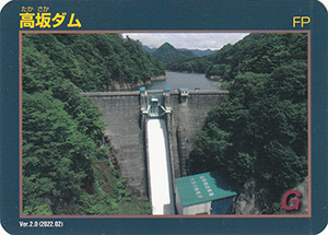
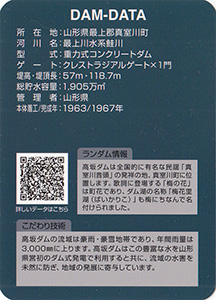
配布場所:最上総合支庁 高坂ダム管理課(9:00~16:00、土・日・祝日・年末年始を除く)
配布日:2022年9月~
取得日:2023年3月28日
取得の追加事項:
ネットで入手した。
ダムデータ
所在地:山形県最上郡真室川町
河川名:最上川水系鮭川
型式:重力式コンクリートダム
ゲート:クレストラジアルゲートX1門
堤高:57m
堤頂長:118.7m
総貯水容量:1905千m3
管理者:山形県
本体着工:1963年
完成年:1967年
表
裏
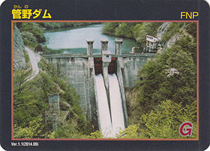
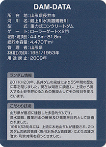
カード種別:ダムカード公認
配布場所:長井ダム管理支所(9:00~17:00、土・日・祝日を含む)
配布日:2014年9月~ 配布終了
取得日:2023年2月12日
取得の追加事項:
ネットで入手した。長井ダムの供用開始によりダム湖に水没したので限定配布され終了した。
ダムデータ
所在地:山形県長井市
河川名:最上川水系置賜野川
型式:重力式コンクリートダム
ゲート:ローラーゲートX2門
堤高:44.5m
堤頂長:81.8m
総貯水容量:4470千m3
管理者:山形県
本体着工:1951年
完成年:1953年
用途廃止:2009年