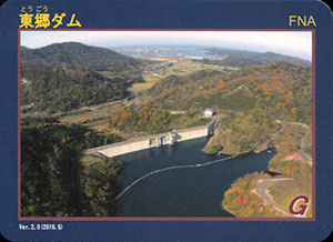
表
裏
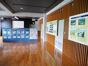
配布場所:旧美歎水源地水道施設(4月~11月、9:00~17:00)、因幡万葉歴史館(9:00~12:00 13:00~17:00、月曜日・祝日の翌日・年末年始を除く)、
配布日:2020年11月~
取得日:2022年11月25日
取得の追加事項:
ネットで入手した。
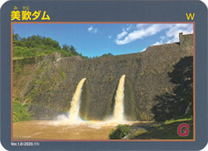
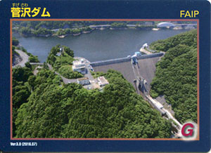
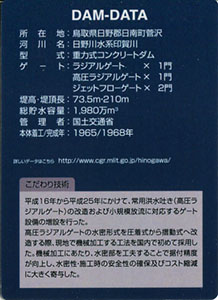
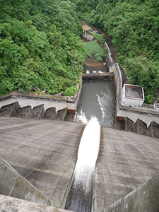
ダムデータ
所在地:鳥取県鳥取市国府町美歎
河川名:千代川水系美歎川
型式:重力式コンクリートダム
ゲート:ゲートレス(自然調節方式)
堤高:27.0m
堤頂長:103.0m
総貯水容量:538千m3(竣工時)
管理者:鳥取県
本体着工:1919年
完成年:1922年
改修年:1998年(砂防改修)
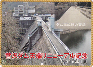
表
裏
配布場所:菅沢ダム管理支所 (9:00~17:00)
配布日:2019年2月24日~2019年5月31日
取得日:2022年11月2日
取得の追加事項:
ネットで入手した。
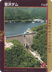
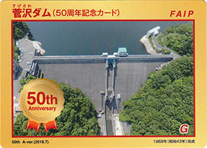
ダムデータ
所在地:鳥取県日野郡日南町菅沢
河川名:日野川水系印賀川
型式:重力式コンクリートダム
ゲート:ラジアルゲートX1門、高圧ラジアルゲートX1門、ジェットフローゲートX2門
堤高:73.5m
堤頂長:210m
総貯水容量:1980万m3
管理者:国土交通省
本体着工:1965年
完成年:1968年
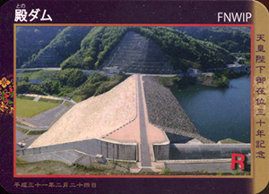
表
裏
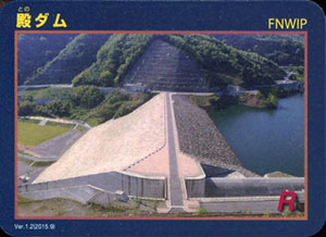
配布場所:殿ダム管理支所 (8:30~17:15、土・日・祝日を含む)
配布日:2022年10月1日~2023年3月31日
取得日:2022年10月19日
取得の追加事項:特になし
ネットで入手した。
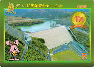
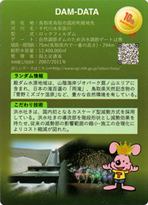
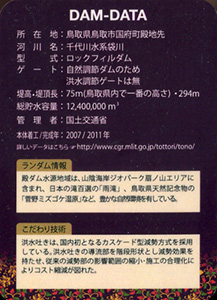
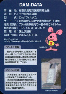
ダムデータ
所在地:鳥取県鳥取市国府町殿地先
河川名:千代川水系袋川
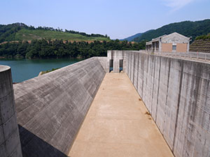
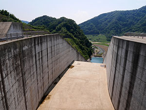
型式:ロックフィルダム
ゲート:自然調節ダムのため洪水調節ゲートは無
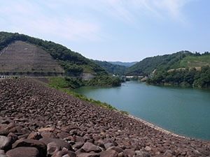
堤高:75m
堤頂長:294m
総貯水容量:1240万m3
管理者:国土交通省
本体着工:2007年
完成年:2011年
表
裏
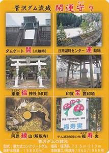
配布場所:菅沢ダム管理支所 (9:00~17:00)
配布日:2018年7月~
取得日:2022年5月31日
取得の追加事項:
ネットで入手した。
表
裏
配布場所:菅沢ダム管理支所 (9:00~17:00)
配布日:2016年1月~
取得日:2022年5月31日
取得の追加事項:
ネットで入手した。
表
裏
配布場所:殿ダム管理支所 (8:30~17:15、土・日・祝日を含む)
配布日:2019年2月24日~2019年5月31日
取得日:2021年6月1日
取得の追加事項:特になし
ネットで入手した。
ダムデータ
所在地:鳥取県鳥取市国府町殿地先
河川名:千代川水系袋川
型式:ロックフィルダム
ゲート:自然調節ダムのため洪水調節ゲートは無
堤高:75m
堤頂長:294m
総貯水容量:1240万m3
管理者:国土交通省
本体着工:2007年
完成年:2011年
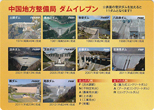
表
裏
配布場所:鳥取県中部総合事務所 県土整備局河川砂防課(9:00~17:00、土日祝日・年末年始を除く)
配布日:2015年5月~
取得日:2020年10月21日
取得の追加事項:現地写真の証明が必要
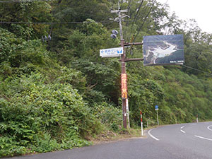
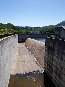
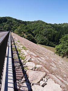
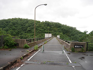
道路標識を見つけてダムへ向かう。
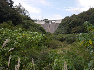
途中堤体が見えた。
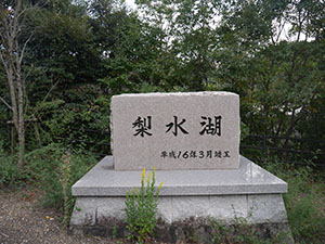
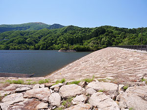
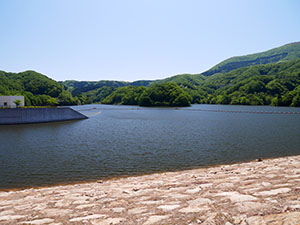
駐車場に着くと梨水湖の石碑が建っていた。
他にダムの案内看板があったと思われる枠が残っていたが、他に銘板もなく東郷ダムとわかるものは「東郷ダム管理事務所」の道路標識のみだった。
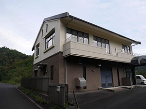
管理事務所
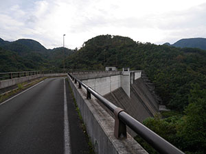
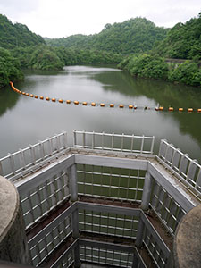
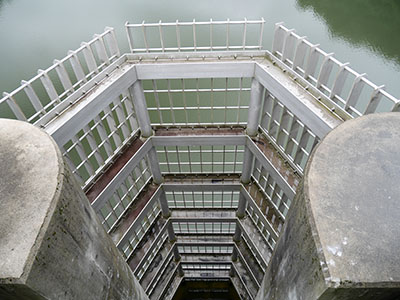
堤体はかなりの大きさ
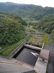
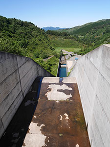
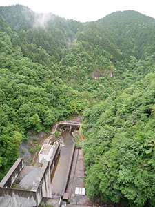
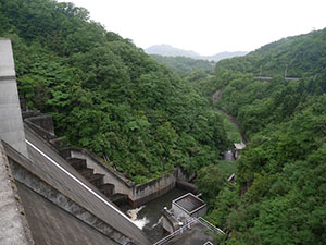
放水路
堤体は途中で屈曲している珍しい形
堤体を奥まで進むと日本海が見えた。
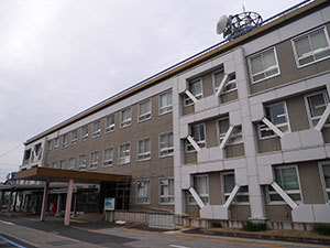
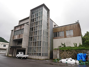
鳥取県中部総合事務所
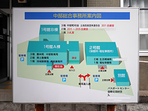
左の建物1号館A棟の2階に県土整備局河川砂防課があった。写真を見せてカードをもらう。
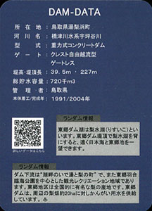
ダムデータ
所在地:鳥取県湯梨浜町
河川名:橋津川水系宇坪谷川
型式:重力式コンクリートダム
ゲート:クレスト自由越流型ゲートレス
堤高:39.5m
堤頂長:227m
総貯水容量:720千m3
管理者:鳥取県
本体着工:1991年
完成年:2004年
表
裏
配布場所:鳥取県鳥取県土整備事務所維持管理課(9:00~17:00、土日祝日・年末年始を除く)、佐治川ダム管理事務所(9:00~17:00、土日祝日・年末年始を含む)
配布日:2014年4月~
取得日:2020年10月21日
取得の追加事項:現地写真の証明が必要
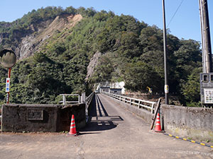
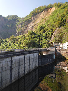
堤体に到着。奥で工事中だった。
堤体
山の斜面が大きく崩れている。土砂崩れだろうか
クレスト自由越流式洪水吐を国内で最初に採用したダムだそうだ。
下流のほうまでは見渡せない。
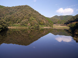
ダム湖
堤体のダム湖側

鳥取県鳥取県土整備事務所の3階にある維持管理課で写真を見せてカードをもらう。
ダムデータ
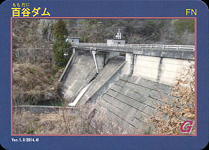
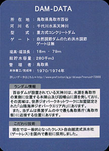
所在地:鳥取県鳥取市百谷
河川名:千代川水系天神川
型式:重力式コンクリートダム
ゲート:自然調節ダムのため洪水調節ゲートは無
堤高:18m
堤頂長:79m
総貯水容量:280千m3
管理者:鳥取県
本体着工:1970年
完成年:1974年
表
裏
配布場所:佐治川ダム管理事務所(9:00~17:00、土日祝日を含む)
配布日:2014年4月~
取得日:2020年9月21日
取得の追加事項:特になし
今年はコロナ禍で国交省管理のダムカードは配布を中止し、地方の独自カードも中止のところが多いが、調べてみると鳥取県では全国緊急事態宣言解除後に配布を再開していたのでもらってきた。
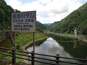
ダム湖の名馬湖。現在はゲート修理のために水位は低いそうだ。
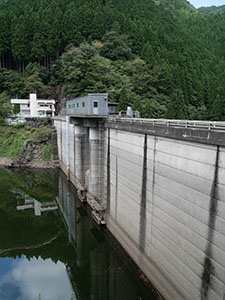
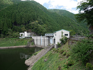
堤体
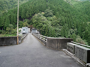
堤体上を歩く
ゲート部
少しだけ水が流れている。山中のため遠景はない。
鳥取県佐治川ダム管理事務所
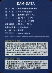
ダムデータ
所在地:鳥取県鳥取市佐治町尾際
河川名:千代川水系佐治川
型式:重力式コンクリートダム
ゲート:クレストゲートX1門、コンジットゲートX2門
堤高:46.5m
堤頂長:105m
総貯水容量:2310千m3
管理者:鳥取県
本体着工:1968年
完成年:1972年
表
裏
配布場所:殿ダム管理支所 (8:30~17:15、土・日・祝日を含む)
配布日:2015年9月~
取得日:2018年7月16日
取得の追加事項:特になし
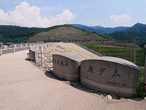
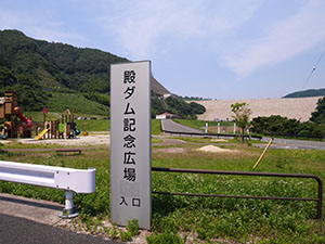
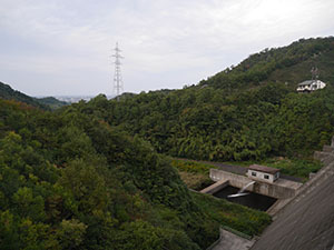
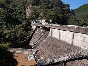
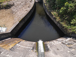
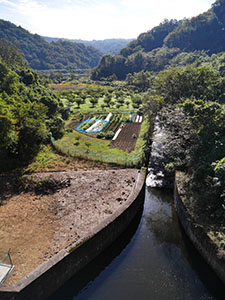
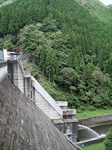
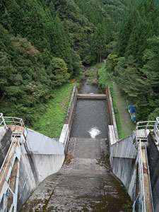
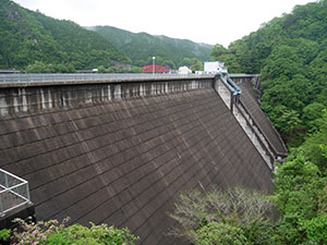
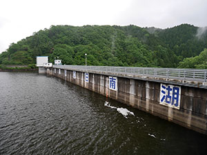
ダム下は殿ダム記念広場になっている。
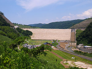
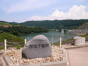
ダム湖は因幡万葉湖
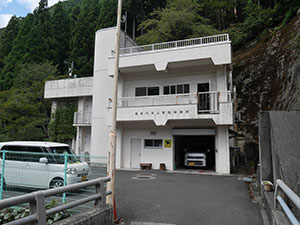
殿ダム管理支所
ダムデータ
所在地:鳥取県鳥取市国府町殿地先
河川名:千代川水系袋川
型式:ロックフィルダム
ゲート:自然調節ダムのため洪水調節ゲートは無
堤高:75m
堤頂長:294m
総貯水容量:1240万m3
管理者:国土交通省
本体着工:2007年
完成年:2011年
表
裏
ダムカードはラミネートされた手作り感満載のカード
配布場所:下蚊屋ダム管理事務所 (8:30~17:30、土日祝日・年末年始を除く)
配布日:2016年4月~
取得日:2018年5月21日
取得の追加事項:特になし
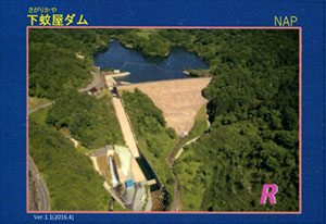
自然越流型水路
ダム湖
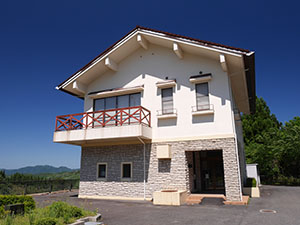
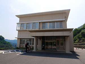
下蚊屋ダム管理事務所
今日はあいにく留守だったため、所定の手続きをして後日ダムカードを郵送してもらう。
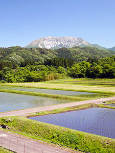
482号線南大山観峰展望駐車場を少し上流に上り、見える大山南壁
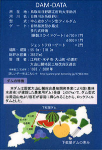
ダムデータ
所在地:鳥取県日野郡江府町大字助沢
河川名:日野川水系俣野川
型式:中心遮水ゾーン型フィルダム
ゲート:自然越流型水路式、多孔式斜樋(鋼製スライドゲート)700X7門・900X1門、ジェットフローゲートX2門
堤高:55.5m
堤頂長:210.0m
総貯水容量:386万m3
管理者:江府町・米子市・大山町・伯耆町・大山山麓地区土地改良区連合
本体着工:1993年
完成年:2001年
表
裏
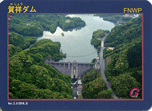
配布場所:菅沢ダム管理支所 (9:00~17:00)
配布日:2016年7月~
取得日:2018年5月19日
取得の追加事項:特になし
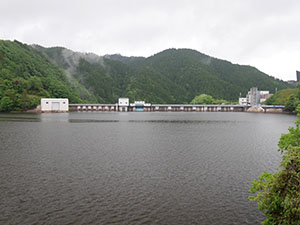
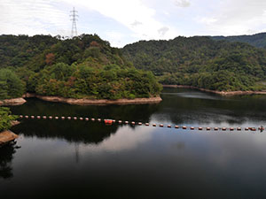
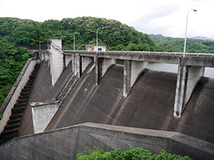
対岸からダム本体を見る
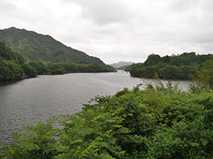
対岸からダム湖を見る
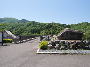
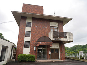
賀祥ダム管理事務所
警備窓口でダムカードをもらえる。
2階のダム資料館は無料で見学できる。
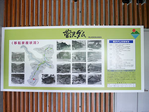
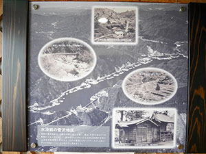
水没した菅沢地区
ダムデータ
所在地:鳥取県日野郡日南町菅沢
河川名:日野川水系印賀川
型式:重力式コンクリートダム
ゲート:ラジアルゲートX1門、高圧ラジアルゲートX1門、ジェットフローゲートX2門
堤高:73.5m
堤頂長:210m
総貯水容量:1980万m3
管理者:国土交通省
本体着工:1965年
完成年:1968年
表
裏
配布場所:賀祥ダム管理事務所 (8:30~17:30、土日祝日を含む)
配布日:2016年3月~
取得日:2018年5月19日
取得の追加事項:簡単なアンケート
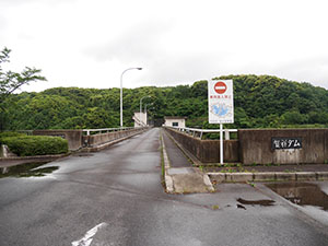
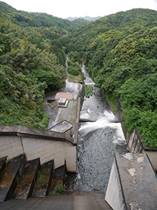
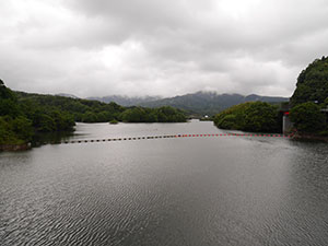
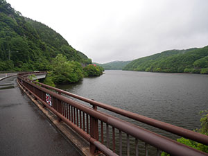
ダム湖
賀祥ダム管理事務所
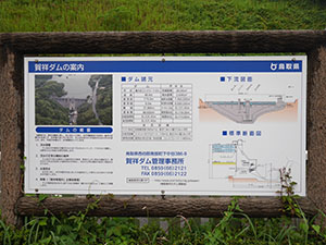
ダム案内
上流の上長田公民館付近から見たダム湖
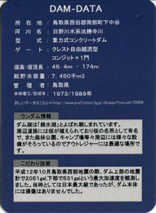
ダムデータ
所在地:鳥取県西伯郡南部町下中谷
河川名:日野川水系法勝寺川
型式:重力式コンクリートダム
ゲート:クレスト自由越流型コンジットX1門
堤高:46.4m
堤頂長:174m
総貯水容量:7450千m3
管理者:鳥取県
本体着工:1973年
完成年:1989年
[2025/7/29追記]
朝鍋ダムのバージョンアップしたダムカードをもらいに賀祥ダムに再訪しました。
今日は朝から晴天でダム湖の写り込みがきれいだったので、管理事務所が開くまでの時間でベストアングルを探して散策しました。
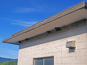
堤体を歩いていると、上空を無数のツバメが飛んでいました。どこかに巣があるのかと探していたらゲート管理棟の軒にたくさんありました。
堤体の向こうの道路をしばらく歩いてみたものの堤体が見える場所がなく、対岸が見えるだけで引き返すことに。
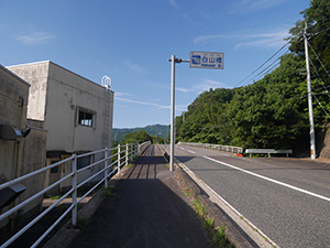
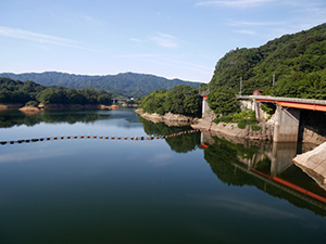
1本目の白山橋を渡る。
対岸の風景もなんだか良い感じです。
2本目の念佛橋を渡る。
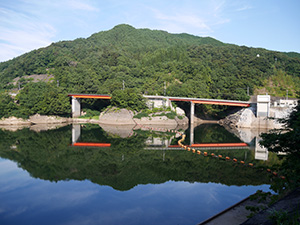
堤体の全体は見えないがいいアングルです。
少し先が公園のようになっていました。
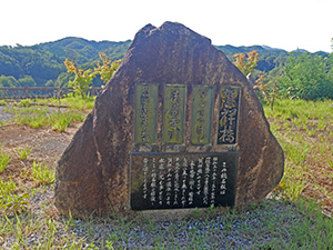
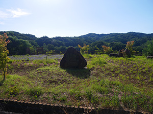
そこにはダム湖に沈んだ賀祥集落に架かっていた2本の橋の銘板が石碑になっていました。
集落はこの下辺りにあったのでしょうか。
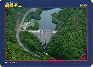
表
裏
配布場所:賀祥ダム管理事務所 (8:30~17:30、ダムへ行った証明(写真等)が必要)
配布日:2016年3月~
取得日:2018年5月19日
取得の追加事項:簡単なアンケート
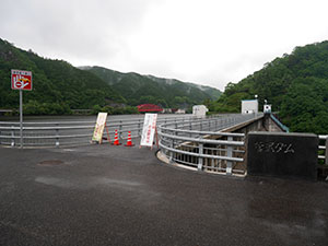
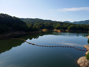
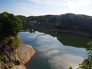
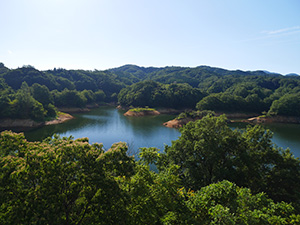
ダム湖
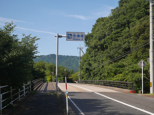
ダム管理事務所は閉鎖されていて、中にあるダム案内も見ることができない。
駐車場にゴミを置き去りにする人が後を絶たず、駐車場も閉鎖されることになったらしい。
ダムデータ
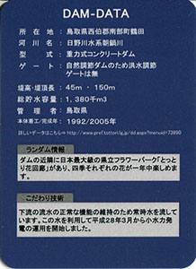
所在地:鳥取県西伯郡南部町鶴田
河川名:日野川水系朝鍋川
型式:重力式コンクリートダム
ゲート:自然調節ダムのため洪水調節ゲートは無
堤高:45m
堤頂長:150m
総貯水容量:1380千m3
管理者:鳥取県
本体着工:1992年
完成年:2005年
何でも集めたくなるのが男のサガ(性)。ゲット!カードコレクション