表
裏
配布場所:津風呂ダム管理所(8:30~17:15、土・日を除く)
配布日:2007年7月~
取得日:2023年8月11日
取得の追加事項:
ネットで入手した。「Ver」がない最初期バージョン。
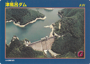
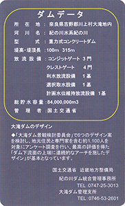
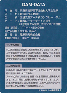
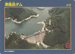
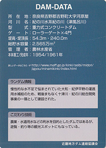
ダムデータ
所在地:奈良県吉野郡吉野町大字河原屋
河川名:紀の川水系紀の川(津風呂川)
型式:重力式コンクリートダム
ゲート:ローラーゲートX4門
堤高:54.3m
堤頂長:240.0m
総貯水容量:2565万m3
管理者:農林水産省
本体着工:1954年
完成年:1961年
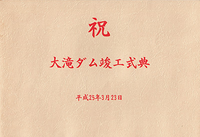
竣工記念カード
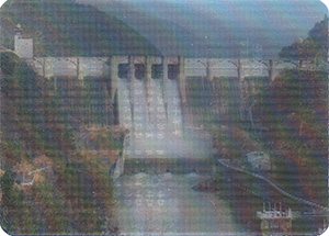
表
裏
カードの傾きで着工前と完成後に変化するレンチキュラーカード
洪水時最高水位到達カード
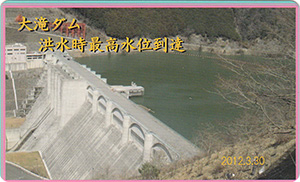
表
裏
配布場所:大滝ダム竣工記念式典
配布日:2013年3月23日
取得日:2025年3月16日
取得の追加事項:式典出席者に配布された。
ネットで入手した。
記念式典台紙
表紙
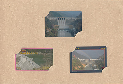
内に3枚のカードがセットされている。
表
裏
配布場所:きなり館 売店(平日 11:30~20:15 土日祝日 11:00~20:15、火曜日休み)、北山村観光センター(道の駅おくとろ)(9:00~17:00、土日祝日を含む)、道の駅 熊野・板屋九郎兵衛の里(平日 10:00~16:00 土日祝日 10:00~17:00、8月を除く第2・第3火曜日休み)
配布日:2024年10月26日~2025年3月31日 各所200枚限定配布終了、増刷分500枚をきなり館で1月15日~配布
取得日:2024年10月31日
取得の追加事項:受け取り時に記名
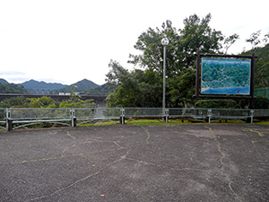
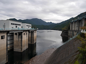
国道から入ってすぐに駐車場があったので停めて歩いてみる。
大きなアーチ式堤体道路だけどゲートがない。
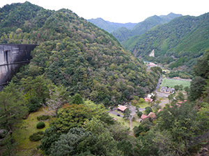
と思ったらダム湖より水位が低くなる上池原集落を守る壁だった。
ダム湖の向こうにゲートが見える。遠いので一度車に戻って向かうことにする。
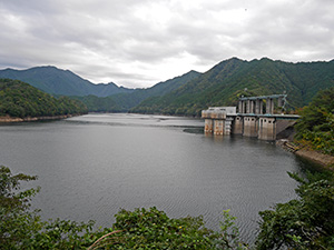
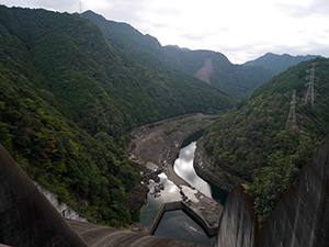
北のほうからここまで来る途中、池原ダムのダム湖に沿って走る部分もあるけれど山奥にあるため範囲も貯水量もとても多い。
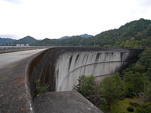
一部すれ違いも厳しい道路を通りゲートの近くまで来ると、こちらにも駐車場があった。
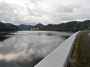
取水口とゲート
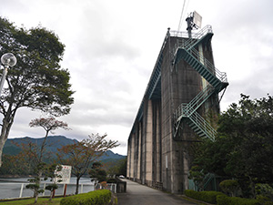
ゲートを見に行くと下流方向が見えるスポットはなかった。
下流方法を覗くと低い位置に道路が通っている。あそこまで行けばゲートを下から見えるな、と思うもののまた戻ってくるのも時間かかりそうなのでここで引き返すことにする。
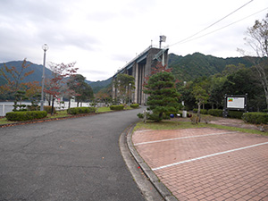
他の場所をまわってオープン時間を過ぎてからきなり館の受付でカードをもらう。
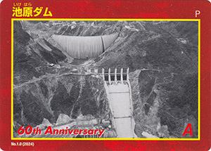
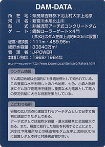
ダムデータ
所在地:奈良県吉野郡下北山村大字上池原
河川名:新宮川水系北山川
型式:非越流形アーチ式コンクリートダム
ゲート:鋼製ローラーゲートX4門
堤高:111m
堤頂長:459.96m
総貯水容量:33840万m3
管理者:J-POWER
本体着工:1962年
完成年:1964年
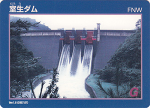
表
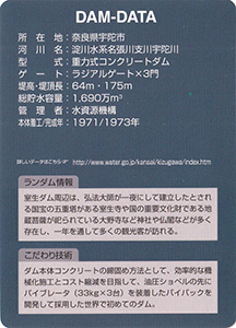
裏
配布場所:室生ダム管理所(8:45~17:15、土・日・祝日を含む)
配布日:2007年7月~
取得日:2024年7月16日
取得の追加事項:
ネットで入手した。
ダムデータ
所在地:奈良県宇陀市
河川名:淀川水系名張川支川宇陀川
型式:重力式コンクリートダム
ゲート:ラジアルゲートX3門
堤高:64m
堤頂長:175m
総貯水容量:1690万m3
管理者:水資源機構
本体着工:1971年
完成年:1973年
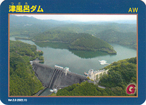
表
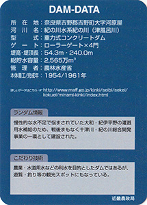
裏
配布場所:津風呂ダム管理所(8:30~17:15、土・日を除く)
配布日:2022年11月~
取得日:2024年6月7日
取得の追加事項:
ネットで入手した。
ダムデータ
所在地:奈良県吉野郡吉野町大字河原屋
河川名:紀の川水系紀の川(津風呂川)
型式:重力式コンクリートダム
ゲート:ローラーゲートX4門
堤高:54.3m
堤頂長:240.0m
総貯水容量:2565万m3
管理者:農林水産省
本体着工:1954年
完成年:1961年
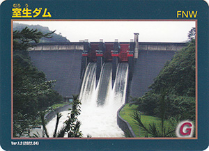
表
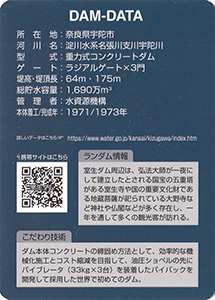
裏
配布場所:室生ダム管理所(8:45~17:15、土・日・祝日を含む)
配布日:2022年4月~
取得日:2024年5月14日
取得の追加事項:
ネットで入手した。
ダムデータ
所在地:奈良県宇陀市
河川名:淀川水系名張川支川宇陀川
型式:重力式コンクリートダム
ゲート:ラジアルゲートX3門
堤高:64m
堤頂長:175m
総貯水容量:1690万m3
管理者:水資源機構
本体着工:1971年
完成年:1973年
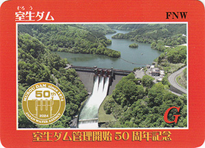
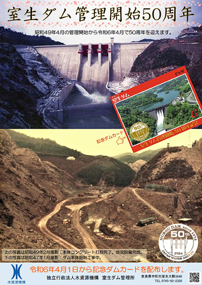
表
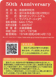
裏
配布場所:室生ダム管理所(8:45~17:15、土・日・祝日を含む)
配布日:2024年4月1日~
取得日:2024年4月4日
取得の追加事項:
ネットで入手した。
ダムデータ
所在地:奈良県宇陀市
河川名:淀川水系名張川支川宇陀川
型式:重力式コンクリートダム
ゲート:ラジアルゲートX3門
堤高:64m
堤頂長:175m
総貯水容量:1690万m3
管理者:水資源機構
本体着工:1971年
完成年:1973年
管理開始:1974年4月11日
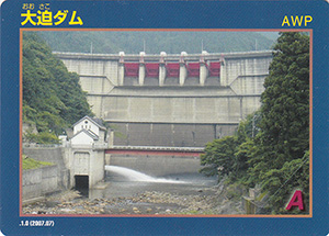
表
裏
配布場所:大迫ダム管理所(9:00~17:30、土・日・祝日を含む)
配布日:2007年7月~
取得日:2024年1月16日
取得の追加事項:
ネットで入手した。
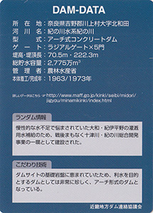
ダムデータ
所在地:奈良県吉野郡川上村大字北和田
河川名:紀の川水系紀の川
型式:アーチ式コンクリートダム
ゲート:ラジアルゲートX5門
堤高:70.5m
堤頂長:222.3m
総貯水容量:2775万m3
管理者:農林水産省
本体着工:1963年
完成年:1973年
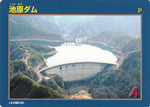
表
裏
配布場所:きなり館 売店(平日 11:30~20:15 土曜 11:00~21:15 日曜 10:00~20:15、第2・第4火曜日休み)、北山川電力所(9:00~17:30、5月1日・土・日・祝日・年末年始を除く)
配布日:2007年7月~
取得日:2024年1月16日
取得の追加事項:
ネットで入手した。
ダムデータ
所在地:奈良県吉野郡下北山村大字上池原
河川名:新宮川水系北山川
型式:非越流形アーチ式コンクリートダム
ゲート:鋼製ローラーゲートX4門
堤高:111m
堤頂長:459.96m
総貯水容量:33840万m3
管理者:電源開発株式会社
本体着工:1962年
完成年:1964年
表
裏
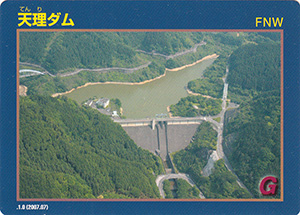
配布場所:天理ダム管理センター(8:30~17:00)
配布日:2007年7月~
取得日:2024年1月16日
取得の追加事項:
ネットで入手した。
ダムデータ
所在地:左岸 奈良県天理市田町、右岸 奈良県天理市長滝町
河川名:大和川水系布留川
型式:重力式コンクリートダム
ゲート:クレストローラーゲートX2門、コンジットバルブX1条、スライドゲートX10門、ローラーゲートX1
門堤高:60.5m
堤頂長:210m
総貯水容量:250万m3
管理者:奈良県
本体着工:1974年
完成年:1979年
表
裏
配布場所:大内ダム管理事務所(9:00~17:00、土・日・祝日を含む)
配布日:2023年11月19日~
取得日:2024年11月24日
取得の追加事項:11日19日の記念行事(やまぶきホール開催)で来場者に配布され、後日残数を管理事務所で配布を始める。
ネットで入手した。
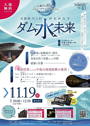
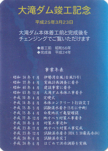
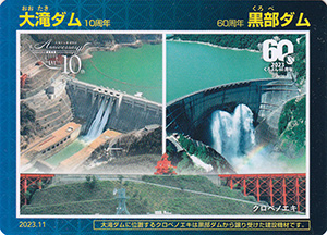
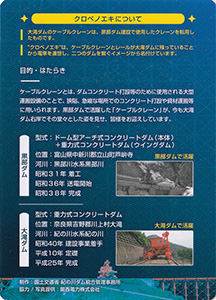
大滝ダム10周年記念行事チラシ
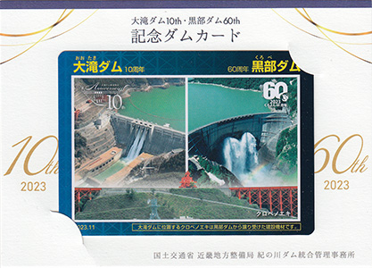
台紙付ダムカード
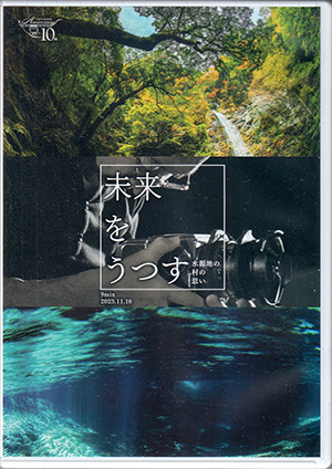
来場者に配布されたDVD
表
裏
配布場所:奥吉野発電所(9:00~17:00、土・日・祝日を含む)
配布日:2007年7月~
取得日:2023年10月2日
取得の追加事項:
ネットで入手した。
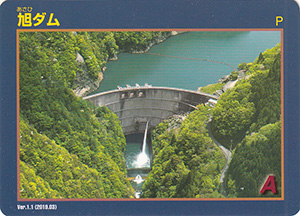
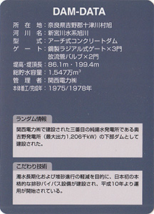
ダムデータ
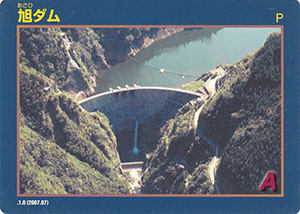
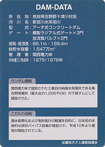
所在地:奈良県吉野郡十津川村旭
河川名:新宮川水系旭川
型式:アーチ式コンクリートダム
ゲート:鋼製ラジアル式ゲートX3門、放流管バルブX2門
堤高:86.1m
堤頂長:199.4m
総貯水容量:1547万m3
管理者:関西電力株式会社
本体着工:1975年
完成年:1978年
表
裏
カード種別:ダムカード公認
配布場所:奥吉野発電所(9:00~17:00、土・日・祝日を含む)
配布日:2007年7月~
取得日:2023年10月2日
取得の追加事項:
ネットで入手した。
ダムデータ
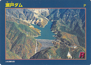
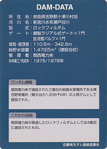
所在地:奈良県吉野郡十津川村旭
河川名:新宮川水系瀬戸谷川
型式:ロックフィルダム
ゲート:鋼製ラジアル式ゲートX1門、放流管バルブX1門
堤高:110.5m
堤頂長:342.8m
総貯水容量:1479万m3(建設当初)
管理者:関西電力株式会社
本体着工:1975年
完成年:1978年
表
裏
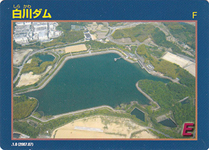
配布場所:白川ダム管理センター(8:30~17:00)
配布日:2007年7月~
取得日:2023年9月18日
取得の追加事項:
ネットで入手した。
ダムデータ
所在地:左岸 奈良県天理市岩屋町、右岸 奈良県天理市和爾町
河川名:大和川水系高瀬川・楢川
型式:均一型アースダム
ゲート:スライドゲートX5門、流量調節バルブX1門
堤高:30m
堤頂長:516m
総貯水容量:156万m3
管理者:奈良県
本体着工:1991年
完成年:1998年
表
裏
配布場所:天理ダム管理センター(8:30~17:00)、奈良土木事務所 管理課(8:30~17:00)
配布日:2007年7月~
取得日:2023年9月18日
取得の追加事項:
ネットで入手した。
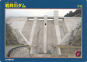
ダムデータ
所在地:左岸 奈良県奈良市鹿野園町、右岸 奈良県奈良市肘塚町
河川名:大和川水系岩井川
型式:重力式コンクリートダム
ゲート:スライドゲートX5門、流量調節バルブX1門
堤高:55m
堤頂長:181m
総貯水容量:81万m3
管理者:奈良県
本体着工:2002年
完成年:2006年
表
裏
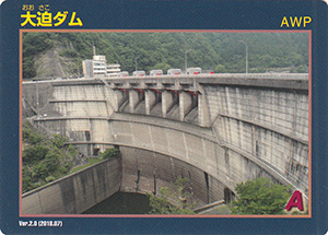
配布場所:大迫ダム管理所(9:00~17:30、土・日・祝日を含む)
配布日:2018年7月~
取得日:2023年8月22日
取得の追加事項:
ネットで入手した。
ダムデータ
所在地:奈良県吉野郡川上村大字北和田
河川名:紀の川水系紀の川
型式:アーチ式コンクリートダム
ゲート:ラジアルゲートX5門
堤高:70.5m
堤頂長:222.3m
総貯水容量:2775万m3
管理者:農林水産省
本体着工:1963年
完成年:1973年
表
裏
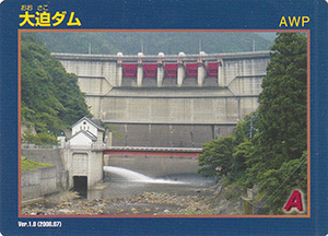
配布場所:大迫ダム管理所(9:00~17:30、土・日・祝日を含む)
配布日:2008年7月~
取得日:2023年8月11日
取得の追加事項:
ネットで入手した。裏に「近畿地方ダム連絡協議会」とあるバージョン
ダムデータ
所在地:奈良県吉野郡川上村大字北和田
河川名:紀の川水系紀の川
型式:アーチ式コンクリートダム
ゲート:ラジアルゲートX5門
堤高:70.5m
堤頂長:222.3m
総貯水容量:2775万m3
管理者:農林水産省
本体着工:1963年
完成年:1973年
表
裏
配布場所:津風呂ダム管理所(8:30~17:15、土・日を除く)
配布日:2008年7月~
取得日:2023年8月11日
取得の追加事項:
ネットで入手した。裏に「近畿地方ダム連絡協議会」とあるバージョン
ダムデータ
所在地:奈良県吉野郡吉野町大字河原屋
河川名:紀の川水系紀の川(津風呂川)
型式:重力式コンクリートダム
ゲート:ローラーゲートX4門
堤高:54.3m
堤頂長:240.0m
総貯水容量:2565万m3
管理者:農林水産省
本体着工:1954年
完成年:1961年
表
裏
配布場所:奥吉野発電所(9:00~17:00、土・日・祝日を含む)
配布日:2018年3月~
取得日:2023年7月2日
取得の追加事項:
ネットで入手した。
ダムデータ
所在地:奈良県吉野郡十津川村旭
河川名:新宮川水系旭川
型式:アーチ式コンクリートダム
ゲート:鋼製ラジアル式ゲートX3門、放流管バルブX2門
堤高:86.1m
堤頂長:199.4m
総貯水容量:1547万m3
管理者:関西電力株式会社
本体着工:1975年
完成年:1978年
表
裏
配布場所:天理ダム管理センター(8:30~17:00)、奈良土木事務所 管理課(8:30~17:00)
配布日:2018年6月~
取得日:2023年7月2日
取得の追加事項:
ネットで入手した。裏に「近畿地方ダム連絡協議会」の表示がある。
ダムデータ
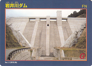
所在地:左岸 奈良県奈良市鹿野園町、右岸 奈良県奈良市肘塚町
河川名:大和川水系岩井川
型式:重力式コンクリートダム
ゲート:スライドゲートX5門、流量調節バルブX1門
堤高:55m
堤頂長:181m
総貯水容量:81万m3
管理者:奈良県
本体着工:2002年
完成年:2006年
何でも集めたくなるのが男のサガ(性)。ゲット!カードコレクション