Ver.3.0
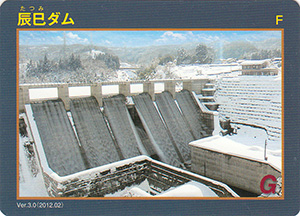
表
裏
Ver.3.1
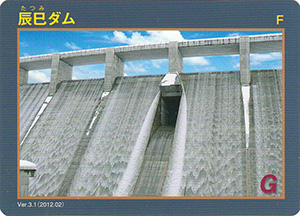
表
裏
配布場所:辰巳ダム建設事務所(土・日・祝日を除く)
配布日:2012年2月~ 配布終了
取得日:2024年10月22日
取得の追加事項:
ネットで入手した。
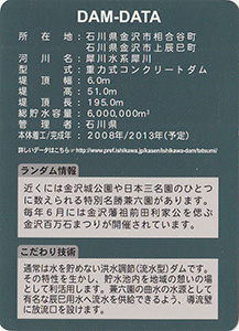
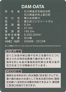
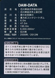
ダムデータ
所在地:石川県金沢市相合谷町・上辰巳町
河川名:犀川水系犀川
型式:重力式コンクリートダム
堤頂幅:6.0m
堤高:47.0m
堤頂長:195.0m
総貯水容量:600万m3
管理者:石川県
本体着工:2008年
完成年:2013年(予定)
表
裏
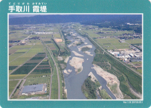
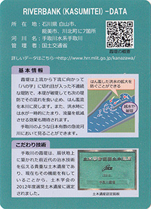
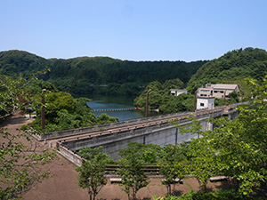
手取川霞堤は1級河川手取川の氾濫を防ぐために築かれた堤防で、扇状地の微高地の島集落を守るために二重、三重に築いて溢れた水を本流に戻す工夫がされている。
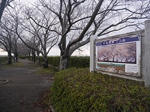
堤防が余りに大きくて平生は気が付かないのだが、カードの写真周辺と思われる川北町桜つつみに行ってきた。
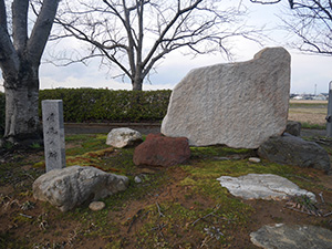
桜つつみの堤防道路には手取川水害60周年記念碑が建っている。
川手を見ると川沿いに1本の堤防が見える。
反対側の町側にも1本堤防が見え、都合3本の堤防が築かれている。
真ん中の堤防道路が2本よりもかなり大きいので、従来は同じくらいの大きさの堤防が3本並んでいたのだろう。
表
裏
配布場所:
配布日:2010年8月~
取得日:2023年9月20日
取得の追加事項:
ネットで入手した。配布されたイベントや条件が全く不明のカードですが、表面の枠部分がキラキラした仕様になっている。2018年7月「森と湖に親しむ旬間」のイベントで九頭竜川ダム・真名川ダムで配布された記念カードの仕様に似ている。こちらのほうが配布は先だけど、竣工式記念で関係者に配布されたものか?
表
裏
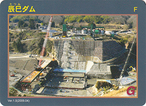
配布場所:辰巳ダム建設事務所(土・日・祝日を除く)
配布日:2009年4月~ 配布終了
取得日:2023年9月20日
取得の追加事項:
ネットで入手した。
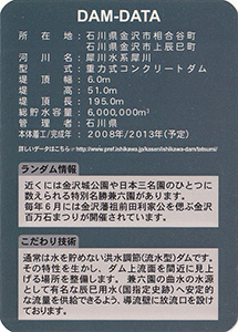
ダムデータ
所在地:石川県金沢市相合谷町・上辰巳町
河川名:犀川水系犀川
型式:重力式コンクリートダム
堤頂幅:6.0m
堤高:51.0m
堤頂長:195.0m
総貯水容量:600万m3
管理者:石川県
本体着工:2008年
完成年:2013年(予定)
表
裏
カード種別:ダムカード非公認
配布場所:石川県庁行政庁舎15F 河川課(土・日・祝日を除く)
配布日:2012年10月~
取得日:2023年7月22日
取得の追加事項:
ネットで入手した。
ダムデータ
所在地:石川県金沢市相合谷町・上辰巳町
河川名:犀川水系犀川
型式:重力式コンクリートダム
堤頂幅:6.0m
堤高:47.0m
堤頂長:195.0m
総貯水容量:600万m3
管理者:石川県
本体着工:2008年
完成年:2012年
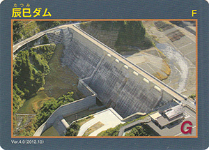
表
裏
配布場所:辰巳ダム建設事務所(土・日・祝日を除く)
配布日:2010年1月~ 配布終了
取得日:2023年7月22日
取得の追加事項:
ネットで入手した。
ダムデータ
所在地:石川県金沢市相合谷町・上辰巳町
河川名:犀川水系犀川
型式:重力式コンクリートダム
堤頂幅:6.0m
堤高:51.0m
堤頂長:195.0m
総貯水容量:600万m3
管理者:石川県
本体着工:2008年
完成年:2013年(予定)

表
裏
カード種別:ダムカード公認
配布場所:珠洲土木事務所(9:00~17:00、土・日・祝日・年末年始を除く)
配布日:2023年5月~
取得日:2023年5月22日
取得の追加事項:ダムへ行った証明(写真等)が必要
始めて小屋ダムを訪れる。
長い洪水吐の先端には深い減勢部がある。
オリフィスの横を堤頂に階段を上って行く。
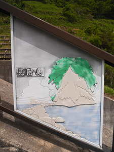
途中手摺り柵にキリコや燈籠山、見附島が描かれている。
小屋ダムが堰き止めている鵜飼川の河口に見附島がある。
通称軍艦島と呼ばれる観光名所は、先日の珠洲地震で船首で土砂崩れがあった。左に描かれる小島は数年前の荒波で消失してしまった。改めて日々自然は移り変わることを実感した。
堤頂にある管理事務所
ダム湖が見える範囲は広くないが、いいロックフィルダムだ。
最後に道の駅すずなり近くの珠洲土木事務所でダムカードをもらう。
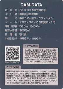
ダムデータ
所在地:石川県珠洲市宝立町柏原
河川名:鵜飼川水系鵜飼川
型式:中央コア一型ロックフィルダム
ゲート:オリフィスによる自然調節X1門
堤高:56.5m
堤頂長:240.0m
総貯水容量:305万m3
管理者:石川県
本体着工:1985年
完成年:1993年
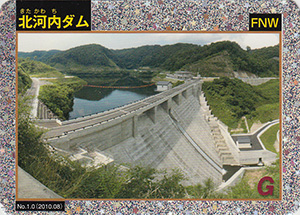
表
裏
カード種別:ダムカード公認
配布場所:奥能登土木総合事務所分室 維持管理課(能登空港ターミナルビル3F)(9:00~17:00、土・日・祝日を除く)
配布日:2022年12月~
取得日:2023年1月6日
取得の追加事項:ダムへ行った証明(写真等)が必要
ネットで入手した。バージョンは更新されていないが、空が見えず少しアップになっている。現在配布のバージョン。
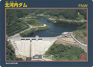
ダムデータ
所在地:石川県鳳珠郡能登町字五十里
河川名:町野川水系河内川
型式:重力式コンクリートダム
堤頂幅:6.0m
堤高:47.0m
堤頂長:140.0m
総貯水容量:286万m3
管理者:石川県
本体着工:2007年
完成年:2010年
表
裏
カード種別:ダムカード公認
配布場所:道の駅瀬女(9:00~17:30、水曜日・年末年始を除く)、手取川総合開発記念館(9:00~16:30、木曜日を除く。12月~3月休館)、白山砂防科学館(9:00~17:00、木曜日・年末年始を除く)
配布日:2007年7月~
取得日:2023年1月1日
取得の追加事項:
ネットで入手した。現在配布しているデザインとは角度が少し違う。手取川ダムはデザインが変わってもバージョンを変更していないようだ。
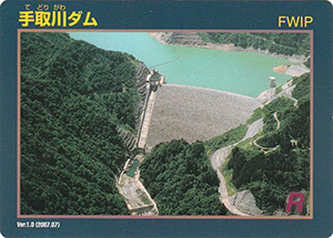
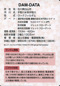
ダムデータ
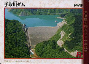
所在地:石川県白山市
河川名:手取川水系手取川
形式:ロックフィルダム
ゲート:選択取水設備鋼製5段式半円形ローラゲート、クレストローラーゲートX2門、放流設備ジェットフローゲート、維持放流設備ジェットフローゲート
堤高:153m
堤頂長:420m
総貯水容量:2億3100万m3
管理者:国土交通省・電源開発(株)
本体着工:1975年
完成年:1980年
表
裏
カード種別:ダムカード公認
配布場所:奥能登土木総合事務所分室 維持管理課(能登空港ターミナルビル3F)(9:00~17:00、土・日・祝日を除く)
配布日:2022年5月~
取得日:2022年7月25日
取得の追加事項:ダムへ行った証明(写真等)が必要
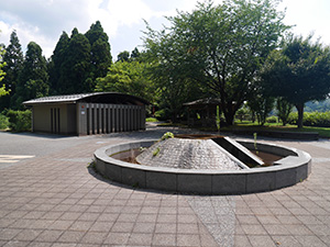
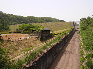
左岸ダムサイト公園
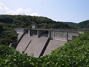
左岸から
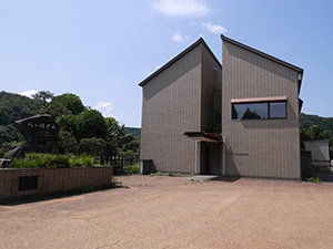
ダム管理事務所
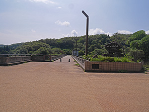
堤体上道路
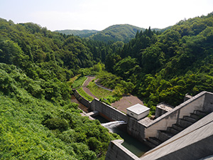
下流方向
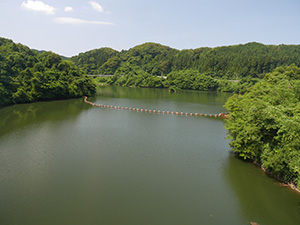
ダム湖 八翠湖
右岸ダムサイト公園から
能登空港ターミナルビル
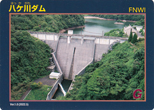
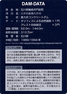
ダムデータ
所在地:石川県輪島市門前町
河川名:八ヶ川水系八ヶ川
型式:重力式コンクリートダム
ゲート:オリフィスによる自然調節X1門、クレスト自由越流X3門
堤高:52.0m
堤頂長:144.0m
総貯水容量:313万m3
管理者:石川県
本体着工:1989年
完成年:1994年
表
裏
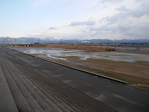
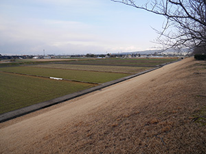
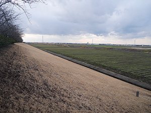
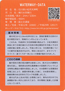
友人からもらった。河川事務所で配布しているらしい。
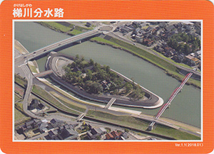
分水路データ
所在地:石川県小松市天神町
河川名:梯川水系梯川
分水路幅:24m
分水路長さ:230m
輪中堤延長:460m
管理者:国土交通省
着工:2000年
完成:2017年
表
裏
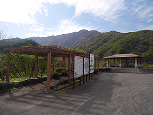
カード種別:ダムカード公認
配布場所:大聖寺川ダム統合管理事務所(9:00~17:00、土・日・祝日、年末年始を除く)
配布日:2020年12月~
取得日:2021年11月4日
取得の追加事項:
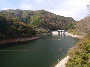
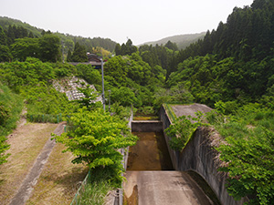
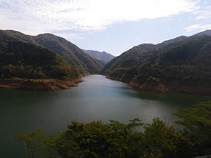
上流の橋から
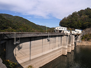
堤体ダム湖側
ダム湖
堤体下流側
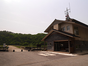
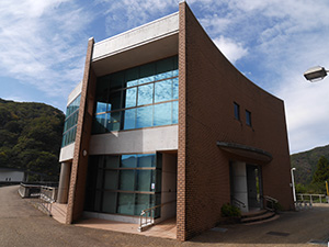
大聖寺川ダム統合管理事務所
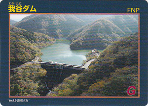
ダムデータ
所在地:石川県加賀市山中温泉我谷町
河川名:大聖寺川水系大聖寺川
型式:重力式コンクリートダム
ゲート:クレストラジアルゲートX2門、コンジットラジアルゲートX1門
堤高:56.5m
堤頂長:126.0m
総貯水容量:1010万m3
管理者:石川県
本体着工:1959年
完成年:1965年
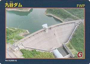
表
裏
カード種別:ダムカード公認
配布場所:大聖寺川ダム統合管理事務所(9:00~17:00、土・日・祝日、年末年始を除く)
配布日:2020年12月~
取得日:2021年11月4日
取得の追加事項:写真提示
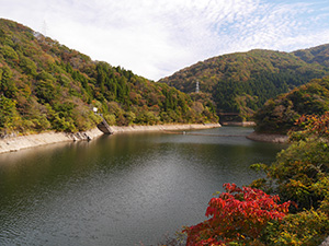
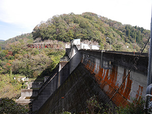
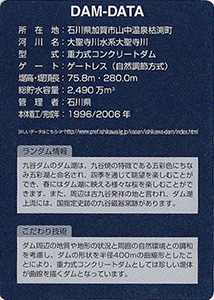
想郷広場から見た富士写ヶ岳
想郷広場からダム湖
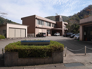
ダム管理事務所
堤体奥に富士写ヶ岳
堤体ダム湖側
堤体下流側
大聖寺川ダム統合管理事務所
ダムデータ
所在地:石川県加賀市山中温泉枯渕町
河川名:大聖寺川水系大聖寺川
型式:重力式コンクリートダム
ゲート:ゲートレス(自然調節方式)
堤高:75.8m
堤頂長:280.0m
総貯水容量:2490万m3
管理者:石川県
本体着工:1996年
完成年:2006年
表
裏
カード種別:ダムカード公認
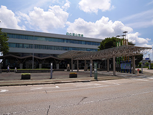
配布場所:石川県庁行政庁舎15F 河川課
配布日:2019年3月11日~(9:00~17:00、土・日・祝日、年末年始を除く)
取得日:2019年3月19日
取得の追加事項:ダム周辺の写真の提示必要
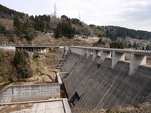
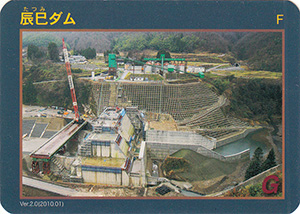
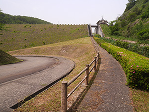
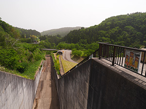
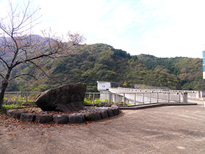
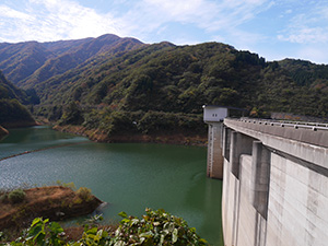
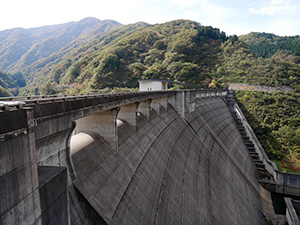
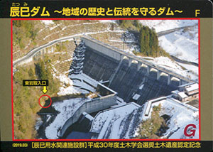
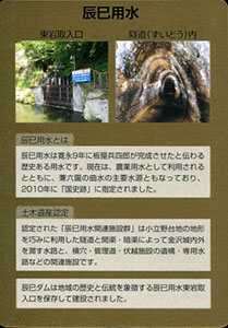
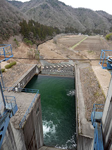
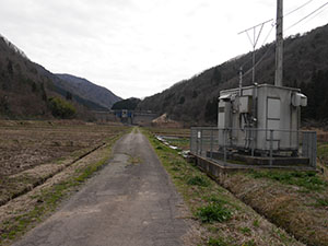
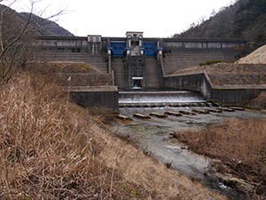
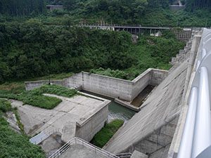
辰巳用水関連施設群が平成30年度の土木遺産に認定された記念カードができたので、久しぶりに辰巳ダムに来ました。
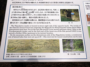
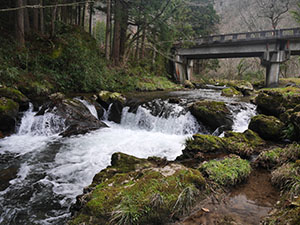
辰巳ダムの下流北側に辰巳用水の取水口になる東岩取入口があります。ダム建設前は河原に下りて近くまで見に行けたのですが、今は遠くから見下ろすしかありません。
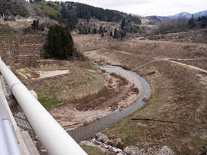
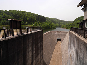
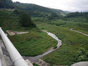
今は農閑期でもあるのでダムは閉じておらず、川がそのまま流れている。
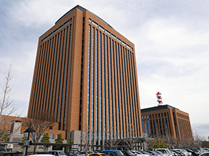
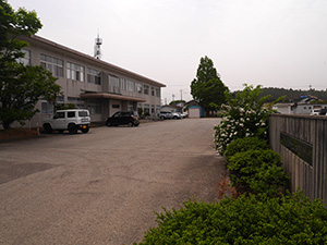
辰巳ダムの証明写真を見せて、石川県庁でカードをもらう。
ダムデータ
所在地:石川県金沢市相合谷町・上辰巳町
河川名:犀川水系犀川
型式:重力式コンクリートダム
堤高:47m
堤頂長:195m
総貯水容量:600万m3
管理者:石川県
本体着工:2008年
完成年:2012年
表
裏
カード種別:ダムカード公認
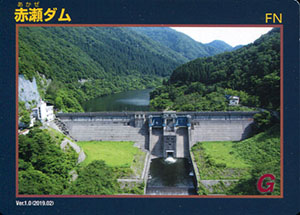
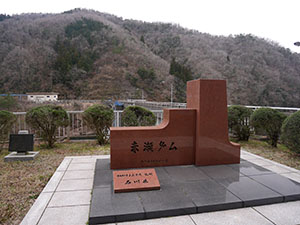
配布場所:赤瀬ダム管理事務所
配布日:2019年3月~(土・日・祝日、年末年始を除く)
取得日:2019年3月19日
取得の追加事項:なし
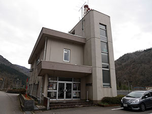
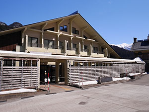
赤瀬ダム管理事務所
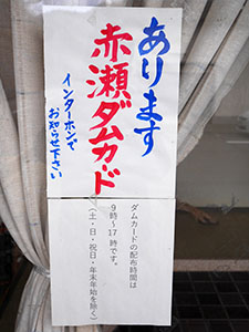
ダムカードを大きく主張している
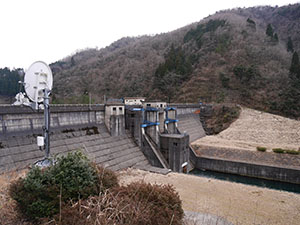
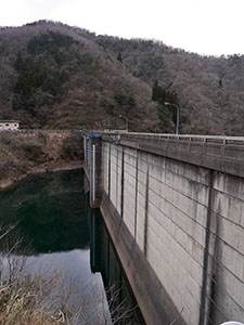
秋から冬は貯水しないようで水位は低かった。
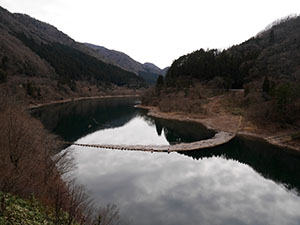
ダム湖
ダム下流の那殿観音(那谷寺奥の院)の入口の橋からダムを見ると、木が邪魔になる。
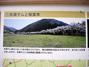
何の木かなと思っていたら桜並木ということです。
少し手前のドコモの基地局からダムに一直線に農道が通っている。
一般車乗り入れ禁止とあったので歩いてダムへと向かう。
ダムのほぼ正面から堤体を見られる。
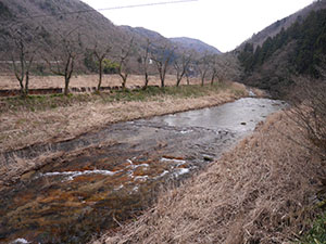
ダムから少し下流に景勝地の荒俣峡があった。初めて来たが小さな滝や奇岩が点在する。
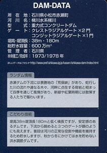
ダムデータ
所在地:石川県小松市赤瀬町
河川名:梯川水系梯川
型式:重力式コンクリートダム
ゲート:クレストラジアルゲートX2門、コンジットラジアルゲートX1門
堤高:38m
堤頂長:180m
総貯水容量:600万m3
管理者:石川県
本体着工:1973年
完成年:1978年
表
裏
カード種別:ダムカード公認
配布場所:道の駅瀬女(水曜日休館)、手取川総合開発記念館(木曜日、12月~3月休館)、白山砂防科学館(木曜日、年末年始休館)
配布日:2019年2月24日~2019年5月31日
取得日:2019年2月24日
取得の追加事項:なし
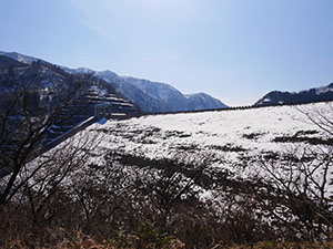
雪を被った堤体が美しい。

ダム湖側は積雪のため駐車場には入れなかった。
今日からの記念カードの配布で、道の駅瀬女はイベントで車いっぱいだろうからと、白峰の白山砂防科学館に初めて来た。配布初日とあって遠方からもカード取得にやってきていた。
記念カードはVer.1.0を基本に、帛のデザインとなっている。
ダムデータ
所在地:石川県白山市
河川名:手取川水系手取川
形式:ロックフィルダム
ゲート:選択取水設備鋼製5段式半円形ローラゲート、クレストローラーゲートX2門、放流設備ジェットフローゲート、維持放流設備ジェットフローゲート
堤高:153m
堤頂長:420m
総貯水容量:2億3100万m3
管理者:国土交通省・電源開発(株)
本体着工:1975年
完成年:1980年
表
裏
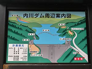
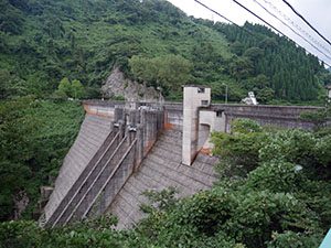
カード種別:ダムカード公認
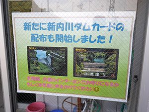
配布場所:内川ダム管理事務所
配布日:2017年6月~(土・日・祝日を除く。日直がいる日は配布あり)
取得日:2017年10月11日
取得の追加事項:簡単なアンケート
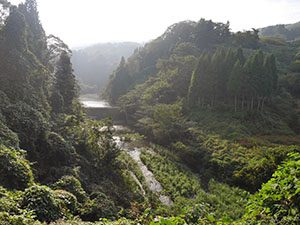
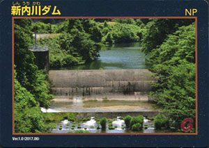
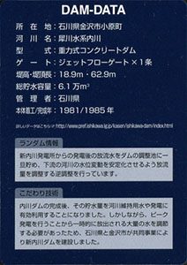
逆光で写りが悪い
新内川ダムは深い谷の中にあり、内川集落から谷をかなり下りダム入口まで来てやっと見えるが、間近まで近づくことができない。
新内川ダムの少し下流、ダムへ至る橋のたもとに旧長坂用水取水口がある。
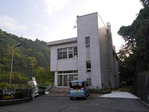
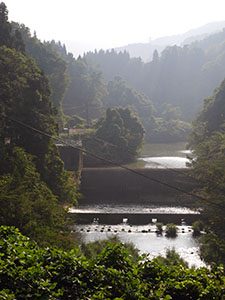
内川ダム管理事務所
ダムデータ
所在地:石川県金沢市小原町
河川名:犀川水系内川
型式:重力式コンクリートダム
ゲート:ジェットフローゲートX1条
堤高:18.9m
堤頂長:62.9m
総貯水容量:6.1万m3
管理者:石川県
本体着工:1981年
完成年:1985年
表
裏
カード種別:ダムカード公認
配布場所:石川県庁行政庁舎15F 河川課
配布日:2016年8月26日~(土・日・祝日を除く)
取得日:2016年8月26日
取得の追加事項:ダム周辺の写真の提示必要
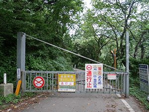
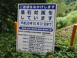
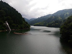
現在はダムに通じる道路が通行止めのため、手前の上寺津ダムまでしか行けない。
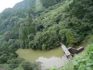
上寺津ダム
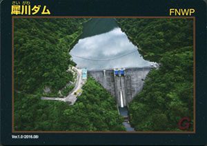
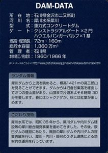
ダムカード
所在地:石川県金沢市二又新町
河川名:犀川水系犀川
型式:重力式コンクリートダム
ゲート:クレストラジアルゲートX2門、ハウエルバンガーバルブX1基
堤高:72m
堤頂長:160m
総貯水容量:1360万m3
管理者:石川県
本体着工:1960年
完成年:1966年
表
裏
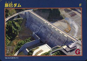
カード種別:ダムカード非公認
配布場所:石川県庁行政庁舎15F 河川課(土・日・祝日を除く)
配布日:(Ver.4.2)2015年11月~
取得日:2016年8月26日
取得の追加事項:ダム周辺の写真の提示必要
洪水調整ダムのため貯水はない
ダムデータ
所在地:石川県金沢市相合谷町・上辰巳町
河川名:犀川水系犀川
型式:重力式コンクリートダム
堤高:47m
堤頂長:195m
総貯水容量:600万m3
管理者:石川県
本体着工:2008年
完成年:2012年
表

裏
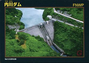
カード種別:ダムカード公認
配布場所:内川ダム管理事務所
配布日:2016年8月26日~(土・日・祝日を除く。日直がいる日は配布あり)
取得日:2016年8月26日
取得の追加事項:なし
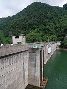

ダムデータ
所在地:石川県金沢市小原町
河川名:犀川水系内川
型式:重力式コンクリートダム
ゲート:クレストラジアルゲートX2門、コンジットラジアルゲートX1門
堤高:81m
堤頂長:172m
総貯水容量:950万m3
管理者:石川県
本体着工:1970年
完成年:1973年
何でも集めたくなるのが男のサガ(性)。ゲット!カードコレクション