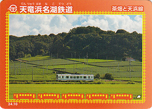
表
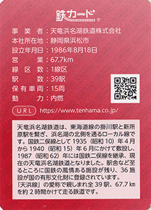
裏
配布場所:イベント配布
配布日:2024年11月1日~2024年11月18日
取得日:2024年11月7日
取得の追加事項:
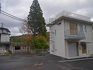
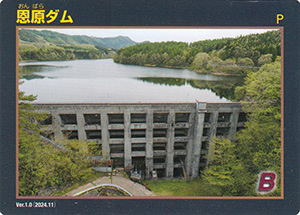
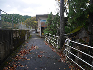
恩原ダムを見に来た。どこにも恩原ダムと書いてない。
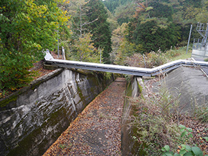
自由越流頂
堤体は歩けるようだ。
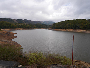
ダム湖
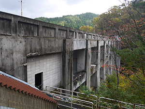
国内に6基しか残っていないバットレスの特徴的な堤体
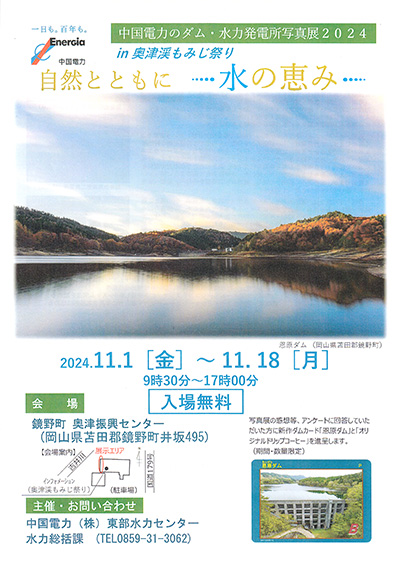
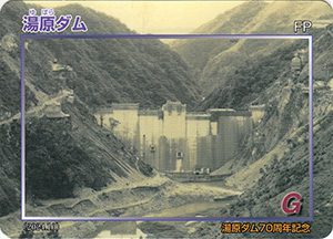
中国電力のダム・水力発電所写真展2024 in 奥津渓もみじ祭り
2024.11.1(金)~11/18(月)
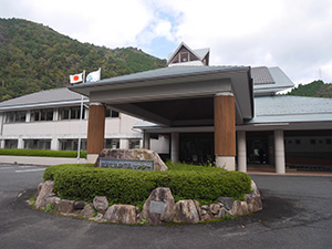
鏡野町奥津振興センターに写真展を見に来た。
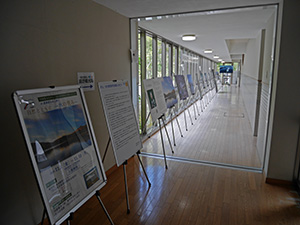
廊下を利用した写真展
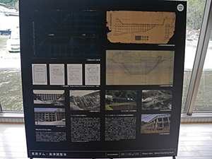
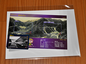
恩原ダムのパネル
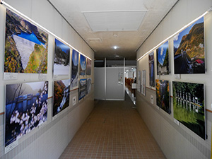
写真展
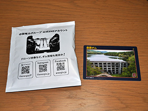
最後にアンケートに答えてダムカードとオリジナルドリップコーヒーをもらいました。
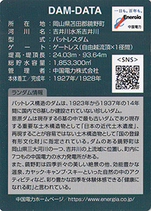
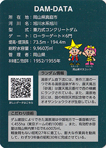
ダムデータ
所在地:岡山県苫田郡鏡野町
河川名:吉井川水系吉井川
型式:バットレスダム
ゲート:ゲートレス(自由越流頂X1径間)
堤高:24.03m
堤頂長:93.64m
総貯水量:1853300m3
管理者:中国電力株式会社
本体着工:1927年
完成年:1928年
表
裏
配布日:2022年4月22日~
取得日:2024年11月7日
取得額:200円
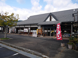
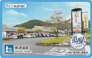
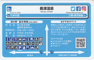
道の駅奥津温泉
道の駅データ
所在地:岡山県苫田郡鏡野町奥津463
供用年月日:平成10年11月3日
休館日:不定休、年末年始
電話:0868-52-7178
おすすめ3品:ひらめ(あまご)の甘露煮、葉わさびしょうゆ漬け、ひらめパイ
表
裏
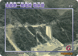
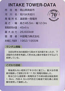
湯原第一発電所 取水塔
表
裏
配布場所:湯原ダム管理事務所(9:00~17:00、土・日・祝日を含む)
配布日:2024年11月1日~2025年1月4日配布終了 1000枚限定
取得日:2024年11月7日
取得の追加事項:
管理事務所でカードをもらう。
袋に入ったセット品をもらった。
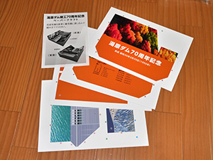
中には通常ダムカードVer.4.1と台紙にセットされた記念ダムカード2枚組、湯原ダムペーパークラフトが入っている。
ダムカード記念台紙
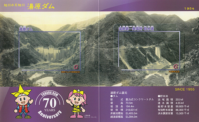
内側
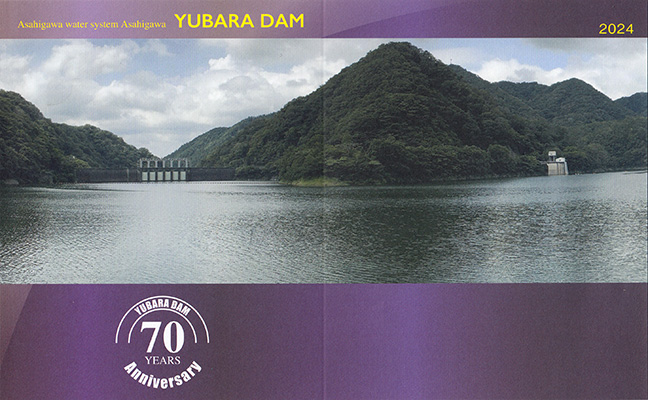
外側
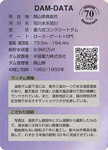
ダムデータ
所在地:岡山県真庭市
河川名:旭川水系旭川
型式:重力式コンクリートダム
ゲート:ローラーゲートX6門
堤高:73.5m
堤頂長:194.4m
総貯水容量:9960万m3
管理者:岡山県
本体着工:1952年
完成年:1955年
表
裏
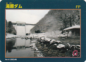
配布場所:湯原ダム管理事務所(9:00~17:00、土・日・祝日を含む)
配布日:2023年9月~
取得日:2024年11月7日
取得の追加事項:
発行日は昨年9月だけど、今年4月に訪堤したときはまだ4.0だったので夏頃か最近切り替わったか。
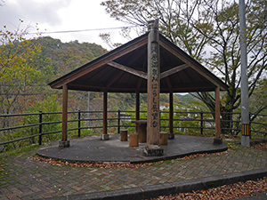
湯原温泉から階段を登ったところの道路沿いの展望台
展望台からの眺望
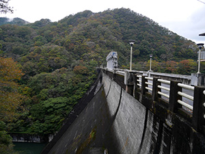
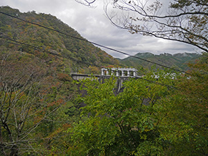
下流すぐの場所に湯原温泉があり、今年4月はここに宿泊して下からの堤体の眺めを堪能した。
ダム堤体
ダム湖
管理事務所でカードをもらう。
ダムデータ
所在地:岡山県真庭市
河川名:旭川水系旭川
型式:重力式コンクリートダム
ゲート:ローラーゲートX6門
堤高:73.5m
堤頂長:194.4m
総貯水容量:9960万m3
管理者:岡山県
本体着工:1952年
完成年:1955年
表
裏
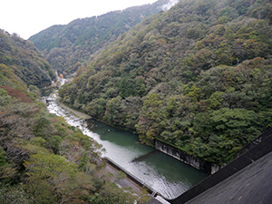
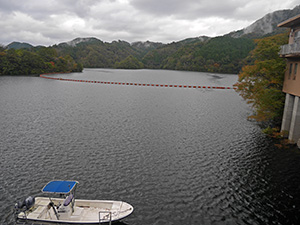
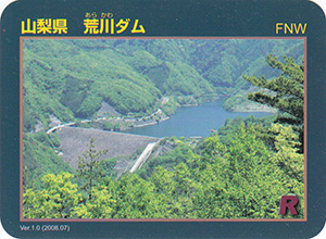
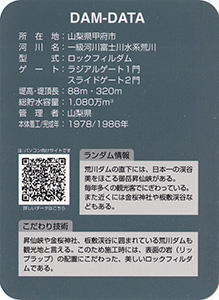
配布場所:荒川ダム管理事務所(8:30~17:15、土・日・祝日を含む)
配布日:2008年7月~
取得日:2024年11月6日
取得の追加事項:
ネットで入手した。
ダムデータ
所在地:山梨県甲府市
河川名:一級河川富士川水系荒川
型式:ロックフィルダム
ゲート:ラジアルゲート1門、スライドゲート2門
堤高:88m
堤頂長:320m
総貯水容量:1080万m3
管理者:山梨県
本体着工:1978年
完成年:1986年
表
裏
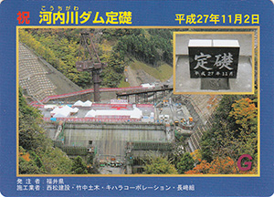
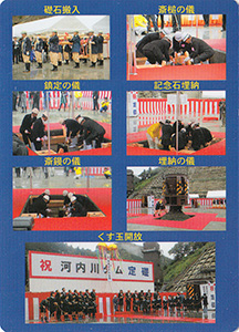
配布場所:河内川ダム定礎式
配布日:2019年11月2日
取得日:2024年11月6日
取得の追加事項:
ネットで入手した。
表
裏
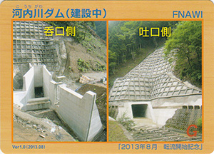
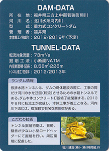
配布場所:河内川ダム建設工事インフォメーションセンター(見学台内)(土日祝日、年末年始を除く)
配布日:2013年8月~
取得日:2024年11月6日
取得の追加事項:
ネットで入手した。
ダムデータ
所在地:福井県三方上中郡若狭町熊川
河川名:北川水系河内川
型式:重力式コンクリートダム
管理者:福井県
本体着工:2012年
完成年:2019年(予定)
表
裏
ネットで入手した。
表
裏
ネットで入手した。
表
裏
ネットで入手した。
表
裏
ネットで入手した。
表
裏
ネットで入手した。
表
裏
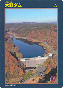
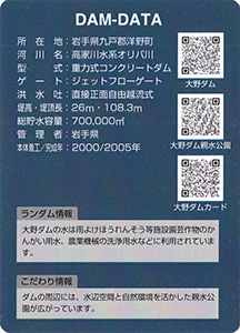
配布場所:洋野町役場 大野庁舎(9:00~17:00)
配布日:2023年10月24日~
取得日:2024年11月5日
取得の追加事項:ダムへ行った証明(写真等)が必要
ネットで入手した。
ダムデータ
所在地:岩手県九戸郡洋野町
河川名:高家川水系オリバ川
型式:重力式コンクリートダム
ゲート:ジェットフローゲート
洪水吐:直接正面自由越流式
堤高:26m
堤頂長:108.3m
総貯水容量:700千m3
管理者:岩手県
本体着工:2000年
完成年:2005年
表
裏
配布日:2022年~
配布場所:イベント配布
ネットで入手した。
表
裏
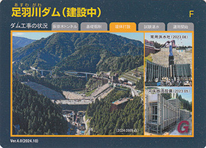
配布場所:まちの市場 こってコテいけだ(8:30~18:30、GWと夏休み期間を除く火曜日休み)、ダムギャラリーあすわ(9:00~16:00、4月~11月の平日のみ)
配布日:2024年10月28日~
取得日:2024年11月5日
取得の追加事項:なし
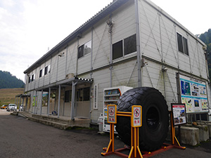
ダムギャラリーあすわの事務所でダムカードをもらう。
中では記念写真用の大きな写真が展示されている。
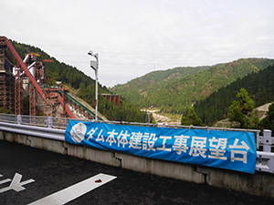
1年ぶりに展望台に行ってみた。
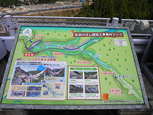
案内板も更新されている。
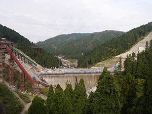
今年は4月から見学できるように変更されていたが、展望台は24時間開放されていて夜間もライトアップされた工事現場を見ることができるようになったようだ。特に暑かった夏場はセメントが固まる気温を考慮して夜間に工事していたそう。
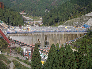
堤体は2割ほど完了している。
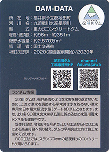
ダムデータ
所在地:福井県今立郡池田町
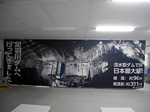
河川名:九頭竜川水系足羽川
型式:重力式コンクリートダム
堤高:約96m
堤頂長:約351m
総貯水容量:約2870万m3
管理者:国土交通省
本体着工:2020年(基礎掘削開始)
完成予定年:2029年
表
裏
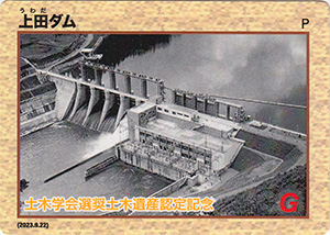
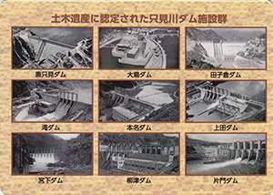
配布場所:東北電力奥会津水力館「みお里」(10:00~16:30、月曜日休み)
配布日:2024年10月10日~2024年11月12日 限定2700枚
取得日:2024年11月4日
取得の追加事項:
ネットで入手した。記念ダムカードは本名・上田・宮下・柳津・片門の5種類の順になくなり次第配布されていく。本名ダムが配布終了し、上田ダムが配布開始になった。
表
裏
ネットで入手した。
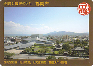
国指定史跡「旧致道館」と文化会館「荘銀タクト鶴岡」
表
裏
配布場所:旧致道館(9:00~16:30、水曜日・年末年始休み)
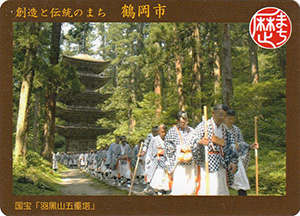
国宝「羽黒山五重塔」
表
裏
配布場所:いでは文化記念館(9:00~16:30、火曜日・年末年始休み)
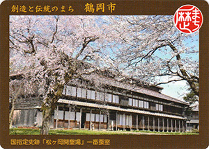
国指定史跡「松ヶ岡開墾場」一番蚕室
表
裏
配布場所:松ヶ岡開墾記念館(9:00~16:00、水曜日・年末年始休み)
配布日:2024年4月13日~
取得日:2024年11月1日
取得の追加事項:
ネットで入手した。鶴岡市の第二弾カード
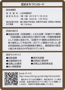
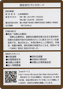
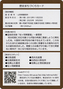
歴史まちづくりカード認定概要
認定都市:山形県鶴岡市
認定年月日:2013年11月22日
重点区域の名称及び面積:鶴岡公園とその周辺地区、羽黒手向地区、羽黒松ヶ岡地区(約951ha)
表
裏
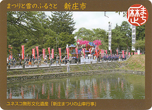
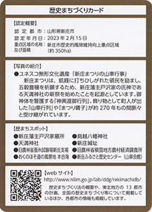
配布場所:新庄ふるさと歴史センター(9:00~16:30、火曜日・祝日の翌日休み)
配布日:2023年8月23日~
取得日:2024年11月1日
取得の追加事項:
ネットで入手した。
歴史まちづくりカード認定概要
認定都市:山形県新庄市
認定年月日:2023年2月15日
重点区域の名称及び面積:新庄市歴史的風致維持向上重点区域(約350ha)
何でも集めたくなるのが男のサガ(性)。ゲット!カードコレクション