表
裏
カード種別:ダムカード非公認
配布場所:宮城県仙台地方ダム総合事務所(8:30~17:15、土・日・祝日を含む)
配布日:
取得日:2023年2月6日
取得の追加事項:
ネットで入手した。
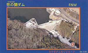
ダムデータ
所在地:宮城県宮城郡利府町森郷字名古曽
河川名:二級河川砂押川水系勿来川
型式:重力式コンクリートダム
放流設備:オリフィス自然調節X1門
目的:洪水調節、流木の正常な機能維持、上水道用水
堤高:23.5m
堤頂長:115m
総貯水容量:110万m3
管理者:宮城県
完成年:1995年
再開発:1999年
表
裏
カード種別:ダムカード非公認
配布場所:宮城県仙台地方ダム総合事務所(8:30~17:15、土・日・祝日を含む)
配布日:
取得日:2023年2月6日
取得の追加事項:
ネットで入手した。
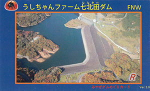
ダムデータ
所在地:宮城県仙台市泉区福岡字赫但木
河川名:二級河川七北田川水系七北田川
型式:中央コア型ロックフィルダム
放流設備:ローラーゲート
目的:洪水調節、上水道用水
堤高:74.0m
堤頂長:420m
総貯水容量:920万m3
管理者:宮城県
完成年:1978年
再開発:1984年
表
裏
カード種別:ダムカード非公認
配布場所:宮城県仙台地方ダム総合事務所(8:30~17:15、土・日・祝日を含む)
配布日:
取得日:2023年2月6日
取得の追加事項:
ネットで入手した。
ダムデータ
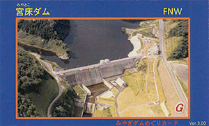
所在地:宮城県黒川郡大和町摺萩
河川名:一級河川鳴瀬川水系宮床川
型式:重力式コンクリートダム
放流設備:オリフィス自然調節X1門
目的:洪水調節、上下水道用水、かんがい用水、流水の正常な機能維持
堤高:48.0m
堤頂長:256m
総貯水容量:540万m3
管理者:宮城県
完成年:1989年
再開発:1997年
表
裏
カード種別:ダムカード非公認
配布場所:宮城県仙台地方ダム総合事務所(8:30~17:15、土・日・祝日を含む)
配布日:
取得日:2023年2月6日
取得の追加事項:
ネットで入手した。
ダムデータ
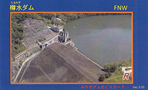
所在地:宮城県名取市高舘川上字長畑
河川名:一級河川名取川水系増田川
型式:中央コア型ロックフィルダム
放流設備:クレストローラーゲート
目的:洪水調節、上水道用水、かんがい用水
堤高:43.0m
堤頂長:256.5m
総貯水容量:470万m3
管理者:宮城県
完成年:1971年
再開発:1976年
表
裏
配布場所:宮城県仙台地方ダム総合事務所(8:30~17:15、土・日・祝日を含む)
配布日:
取得日:2023年2月6日
取得の追加事項:
ネットで入手した。
ダムデータ
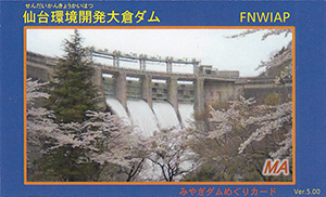
所在地:宮城県仙台市青葉区大倉字岩下
河川名:一級河川名取川水系大倉川
型式:アーチ式コンクリートダム
放流設備:クレストローラーゲートX4門
目的:洪水調節、水道用水、工業用水、かんがい用水、発電
堤高:82.0m
堤頂長:323.0m
総貯水容量:2800万m3
管理者:宮城県
本体着工:1958年
完成年:1962年
表
裏
ネットで入手した。
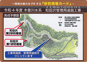
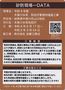
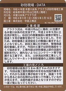
砂防現場データ
所在地:岐阜県中津川市山口地先
河川名:木曽川水系和田沢
工期:令和4年6月17日~令和5年3月24日
施工者:株式会社加藤工務店
表
裏
ネットで入手した。
砂防現場データ
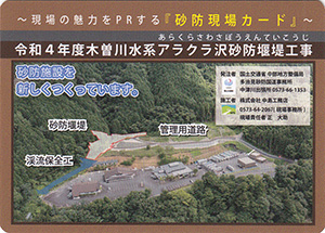
所在地:岐阜県中津川市山口地先(賤母)
河川名:木曽川水系アラクラ沢
工期:令和4年9月1日~令和5年3月16日
施工者:株式会社中島工務店
表
裏
配布先:土岐市ネイチャーセンター
配布日:2017年10月~
取得日:2023年2月6日
ネットで入手した。
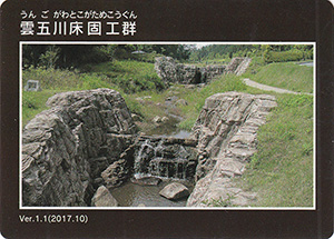
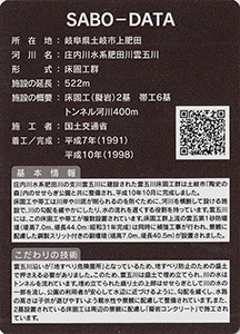
砂防施設データ
所在地:岐阜県土岐市上肥田
河川名:庄内川水系肥田川雲五川
形式:床固工群
施設の延長:522m
施設の概要:床固工(擬岩)2基、帯工6基
施工者:国土交通省
着工:1991年
完成:1998年
表
裏
ネットで入手した。
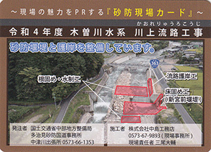
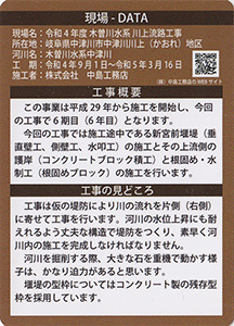
現場データ
所在地:岐阜県中津川市中津川川上地区
河川名:木曽川水系中津川
工期:令和4年9月1日~令和5年3月16日
施工者:株式会社中島工務店
表
裏
配布先:多治見駅観光案内所、陶部創造館、多治見市産業観光課、モザイクタイルミュージック
配布日:2017年10月~
取得日:2023年2月6日
ネットで入手した。
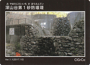
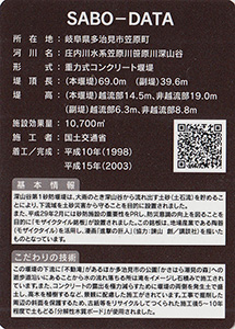
砂防施設データ
所在地:岐阜県多治見市笠原町
河川名:庄内川水系笠原川笹原川深山谷
形式:重力式コンクリート堰堤
堤頂長:(本堰堤)69.0m(副堤)39.6m
堤高:(本堰堤)14.5m(副堤)6.3m
施設効果量:10700m3
施工者:国土交通省
着工:1988年
完成:2003年
表
裏
配布先:多治見駅観光案内所、陶部創造館、多治見市産業観光課、モザイクタイルミュージック
配布日:2021年3月~
取得日:2023年2月6日
ネットで入手した。
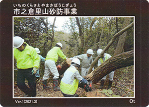
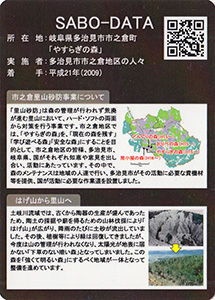
砂防施設データ
所在地:岐阜県多治見市市之倉町「やすらぎの森」
実施者:多治見市市之倉地区の人々
着手:2009年
表
裏
配布先:大桑村役場、道の駅 大桑、大桑村野尻出張所
配布日:2021年3月~
取得日:2023年2月6日
ネットで入手した。
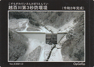
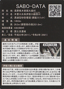
砂防施設データ
所在地:長野県木曽郡大桑村
河川名:木曽川水系伊奈川越百川
形式:透過型砂防堰堤(鋼製スリット)
堤頂長:149.0m
堤高:26.5m(鋼管部の高さ21.0m)
施設効果量:438960m3
施工者:国土交通省
着工:2011年
完成:2021年
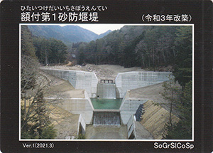
表
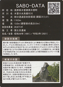
裏
配布先:南木曽駅観光案内所、妻籠観光案内所、福沢桃介記念館
配布日:2021年3月~
取得日:2023年2月6日
ネットで入手した。
砂防施設データ
所在地:長野県木曽郡南木曽町
河川名:木曽川水系額付川
形式:部分透過型砂防堰堤(鋼製スリット)
堤頂長:116.5m
堤高:13.0m(鋼管部の高さ2.0m)
施設効果量:20871m3
施工者:国土交通省
着工:1981年
完成:2021年
表
裏
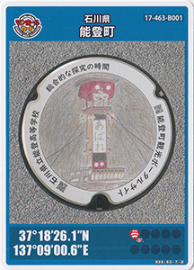
配布場所:コンセールのと(たびスタ)
配布日:2023年1月28日~(9:00~18:00)
取得日:2023年2月6日
取得の追加条件:特になし
マンホールの設置場所:
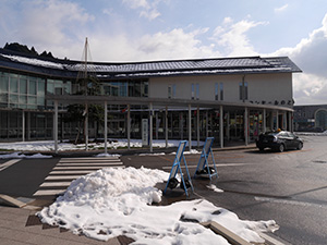
能登町役場の隣にあるコンセールのと
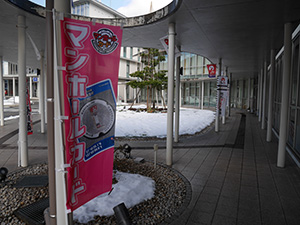
入口にマンホールカード旗も立っていた。実際のマンホールはどこか?周辺にはなかったようで、またいつか探してみたい。
表
裏
ネットで入手した。
表
裏
ネットで入手した。
表
裏
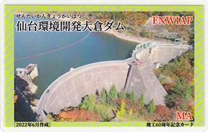
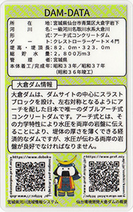
配布場所:大倉ダム管理事務所
配布日:2022年7月~
取得日:2023年2月5日
取得の追加事項:
ネットで入手した。
ダムデータ
所在地:宮城県仙台市青葉区大倉字岩下
河川名:一級河川名取川水系大倉川
型式:アーチ式コンクリートダム
ゲート:クレストローラーゲートX4門
堤高:82.0m
堤頂長:323.0m
総貯水容量:2800万m3
管理者:宮城県
本体着工:1958年
完成年:1962年(1961年竣工)
表
裏
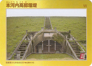
カード種別:ダムカード公認
配布場所:長崎振興局 河川課(9:00~17:00、土・日・祝日・年末年始を除く)
配布日:2017年11月18日~2019年4月24日 限定500枚
取得日:2023年2月4日
取得の追加事項:長崎水害緊急ダム事業で整備した5ダム(本河内高部ダム、本河内低部ダム、西山ダム、中尾ダム、浦上ダム)の通常版ダムカードを提示する。
ネットで入手した。
ダムデータ
所在地:長崎県長崎市本河内3丁目
河川名:中島川水系中島川
型式:土堰堤(アースダム)
ゲート:自然越流方式
堤高:18.7m
堤頂長:128m
総貯水容量:約367千m3
管理者:長崎県(旧堤体は長崎市)
建設年代:1891年
表
裏
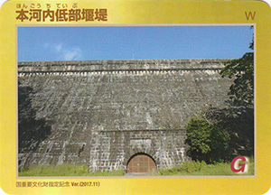
カード種別:ダムカード公認
配布場所:長崎振興局 河川課(9:00~17:00、土・日・祝日・年末年始を除く)
配布日:2017年11月18日~2019年4月24日 限定500枚
取得日:2023年2月4日
取得の追加事項:長崎水害緊急ダム事業で整備した5ダム(本河内高部ダム、本河内低部ダム、西山ダム、中尾ダム、浦上ダム)の通常版ダムカードを提示する。
ネットで入手した。
ダムデータ
所在地:長崎県長崎市本河内2丁目
河川名:中島川水系中島川
型式:粗石コンクリート造重力ダム(重力式コンクリートダム)
ゲート:自然越流方式
堤高:26.8m
堤頂長:130.7m
総貯水容量:608千m3
管理者:長崎県
建設年代:1903年
表
裏
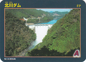
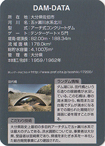
カード種別:ダムカード公認
配布場所:北川ダム管理事務所(9:30~12:00 13:00~16:00、土・日・祝日を含む)
配布日:2015年3月~
取得日:2023年2月4日
取得の追加事項:
ネットで入手した。
ダムデータ
所在地:大分県佐伯市
河川名:五ヶ瀬川水系北川
型式:アーチ式コンクリートダム
ゲート:テンターゲートX5門
堤高:82.00m
堤頂長:188.34m
流域面積:178.0km2
総貯水容量:4100万m3
管理者:大分県
本体着工:1959年
完成年:1962年
何でも集めたくなるのが男のサガ(性)。ゲット!カードコレクション